Back ماتواكا (فرجينيا) Arabic ماتوکا، ویرجینیا AZB Matoaca Catalan Матоака (Виргини) CE Matoaca CEB Matoaca, Virginia Welsh Matoaca (Virginia) Spanish Matoaca (Virginia) Basque ماتوکا، ویرجینیا Persian Matoaca Italian
Matoaca, Virginia | |
|---|---|
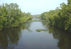
 The Appomattox River at Matoaca | |
 Location of Matoaca, Virginia | |
| Coordinates: 37°13′41″N 77°28′14″W / 37.22806°N 77.47056°W | |
| Country | United States |
| State | Virginia |
| County | Chesterfield |
| Area | |
| • Total | 2.7 sq mi (6.9 km2) |
| • Land | 2.5 sq mi (6.6 km2) |
| • Water | 0.1 sq mi (0.3 km2) |
| Elevation | 141 ft (43 m) |
| Population (2020) | |
| • Total | 2,725 |
| • Density | 1,000/sq mi (390/km2) |
| Time zone | UTC−5 (Eastern (EST)) |
| • Summer (DST) | UTC−4 (EDT) |
| FIPS code | 51-50136[1] |
| GNIS feature ID | 1497010[2] |
Matoaca is a census-designated place (CDP) in Chesterfield County, Virginia, United States. The population was 2,725 at the 2020 census.[3] It is named after the Pamunkey princess Matoaka who was better known by her nickname "Pocahontas".[4] It was near the site of an Appomattoc village Matoka or Matoks, which was reputedly her girlhood home, and the palace town of the weroansqua Oppussoquionuske.[5]
In 2016 it was listed as No. 42 in CNN Money's Top 50 Places to Live in the United States.[6]
- ^ "U.S. Census website". United States Census Bureau. Retrieved January 31, 2008.
- ^ "US Board on Geographic Names". United States Geological Survey. October 25, 2007. Retrieved January 31, 2008.
- ^ "Profile of General Population and Housing Characteristics: 2020 Demographic Profile Data (DP-1): Matoaca CDP, Virginia". United States Census Bureau. Retrieved October 13, 2024.
- ^ Gannett, Henry (1905). The Origin of Certain Place Names in the United States. U.S. Government Printing Office. p. 203.
- ^ Francis E. Lutz, 1954, Chesterfield - An Old Virginia County, p. 10, 15.
- ^ Time, Sept. 19, 2016