Back نهر ميرسيد Arabic نهر ميرسيد ARZ Мерсед (рака) Byelorussian Мърсед (река) Bulgarian Merced River CEB Merced Czech Мерсед (юханшыв) CV Merced River German Río Merced Spanish رود مرسدس Persian
| Merced River | |
|---|---|
 The Merced River in Yosemite Valley | |
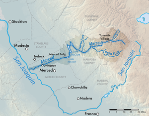
 Map of the Merced River | |
| Etymology | Spanish El Río de Nuestra Señora de la Merced ("River of our Lady of Mercy") given to the river by Spanish explorer Gabriel Moraga |
| Location | |
| Country | United States |
| State | California |
| Region | Yosemite National Park, Central Valley (California) |
| Cities | El Portal, Livingston |
| Physical characteristics | |
| Source | Confluence of Merced Peak and Triple Peak Forks |
| • location | Yosemite National Park, Madera County |
| • coordinates | 37°41′47.05″N 119°20′53.54″W / 37.6964028°N 119.3482056°W |
| • elevation | 8,017 ft (2,444 m) |
| Mouth | San Joaquin River |
• location | Hills Ferry, Stanislaus County |
• coordinates | 37°20′57″N 120°58′32″W / 37.34917°N 120.97556°W |
• elevation | 56 ft (17 m) |
| Length | 145 mi (233 km)[1] |
| Basin size | 1,726 sq mi (4,470 km2) |
| Discharge | |
| • location | Bagby, near Lake McClure |
| • average | 1,185 cu ft/s (33.6 m3/s) |
| • minimum | 19 cu ft/s (0.54 m3/s) |
| • maximum | 92,500 cu ft/s (2,620 m3/s) |
| Basin features | |
| Tributaries | |
| • left | Red Peak Fork, Illilouette Creek, Bridalveil Creek, South Fork Merced River |
| • right | Triple Peak Fork, Lyell Fork, Sunrise Creek, Tenaya Creek, Yosemite Creek, Cascade Creek, North Fork Merced River, Dry Creek |
| Type | Wild, Scenic, Recreational |
| Designated | November 2, 1987 |

The Merced River (/mɜːrˈsɛd/), in the central part of the U.S. state of California, is a 145-mile (233 km)-long[1] tributary of the San Joaquin River flowing from the Sierra Nevada into the San Joaquin Valley. It is most well known for its swift and steep course through the southern part of Yosemite National Park, where it is the primary watercourse flowing through Yosemite Valley. The river's character changes dramatically once it reaches the plains of the agricultural San Joaquin Valley, where it becomes a slow-moving meandering stream.[2]
The river first formed as the Sierra Nevada rose about 10 million years ago, and sediment eroded from its canyon helped form the flat floor of the San Joaquin Valley. Glaciation during the ice ages carved the high elevation parts of the watershed, including Yosemite Valley, into their present shape. Historically, there was an extensive riparian zone which provided habitat for millions of migrating birds, and the river had one of the southernmost runs of chinook salmon in North America.
Miwok and Paiute people lived along the river for thousands of years before Spanish and Mexican military expeditions passed through in the early 19th century. The California Gold Rush brought many people into California and some settled in towns along the lower Merced River. A railroad was built along the Merced canyon, enabling mining and logging in the upper watershed, and later carrying tourists to Yosemite National Park. Conflicts between settlers and Native Americans resulted in wars, including the expulsion of the Ahwahnechee from Yosemite.
Large-scale irrigation was introduced to the San Joaquin Valley in the late 19th century, and led to the construction of numerous state, federal and privately owned dams, which blocked migrating salmon and caused a large decline in riparian habitat. Diversion of water for irrigation often reduces the river to a small stream by the time it reaches its mouth. Efforts to mitigate environmental damage include habitat conservation work, re-establishment of historic streamflow patterns, and the construction of a salmon hatchery.
- ^ a b U.S. Geological Survey. National Hydrography Dataset high-resolution flowline data. The National Map Archived 2012-03-29 at the Wayback Machine, accessed March 11, 2011
- ^ Fowler, Mia (1990). Missouri River management plan : Holter Dam to Great Falls, 1990 through 1994 /. [Helena?, Mont.]: The Dept. doi:10.5962/bhl.title.101406.