Back ميرير Arabic Merir CEB Merir German Merir Spanish Melieli French Merir Italian メリール島 Japanese Meriras Lithuanian Мерир Macedonian Merir Polish
This article needs additional citations for verification. (November 2020) |

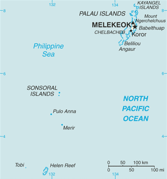
Merir, or Melieli, is a small outlying island of the Palau group, in the western Pacific Ocean. The island has an area of 0.90 square kilometres (0.35 sq mi) and is very long and narrow, stretching approximately 2.4 kilometres (1.5 mi) from north to south but only approximately 667 metres (2,190 ft) at its widest point. It is uninhabited. An abandoned village which previously hosted a radio station lies in the northwest part of the island.
The island itself is covered with trees but it is surrounded by a beach around which is a lagoon. Outside this, the whole is surrounded by a coral reef and the open ocean.
Together with the islands of Sonsorol and Fana, which are 110 kilometres (59 nmi; 68 mi) to the northwest, and the island of Pulo Anna 50 kilometres (27 nmi; 31 mi) away, Merir forms the state of Sonsorol in the Republic of Palau.
The first recorded sighting of Merir by Europeans was by the Spanish missionary expedition commanded by Sargento Mayor Francisco Padilla on board of the patache Santísima Trinidad in November 1710.[1]
- ^ Rienzi, M.L. Historia de la Oceanía, o quinta parte del mundo, Barcelona, 1845-1846, vol.2, p.78