Back Historia meteorológica del huracán Katrina Spanish História meteorológica do furacão Katrina Portuguese Storm history of Hurricane Katrina SIMPLE 2005年飓风卡特里娜的气象历史 Chinese
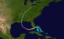
 Track of Hurricane Katrina | |
| Meteorological history | |
|---|---|
| Formed | August 23, 2005 |
| Extratropical | August 30, 2005 |
| Dissipated | September 7, 2005[nb 1] |
| Duration | 8 days (tropical cyclone phase only) 30 days (including precursor and extratropical phases) |
| Category 5 major hurricane | |
| 1-minute sustained (SSHWS/NWS) | |
| Highest winds | 175 mph (280 km/h) |
| Lowest pressure | 902 mbar (hPa); 26.64 inHg |
| Overall effects | |
| Areas affected | The Bahamas, United States Gulf Coast (especially Louisiana and Mississippi), Mississippi River Valley, Eastern Canada |
Part of the 2005 Atlantic hurricane season | |
Hurricane Katrina was a devastating tropical cyclone that had a long and complex meteorological history, spanning a month from August 8 to September 7, 2005. Katrina's origins can be traced to the mid-level remnants of Tropical Depression Ten, a tropical wave, and an upper tropospheric trough. The tropical depression emerged as a wave off West Africa on August 8, the second wave followed on August 11, while the trough factored into tropical cyclogenesis between August 17 and 23. The mid-level remnants of Tropical Depression Ten merged with the second tropical wave on August 19 while located north of Hispaniola. Subsequent interaction with the trough spurred convective development, resulting in the formation of Tropical Depression Twelve over the Bahamas on August 23. Deep convection soon blossomed and following the development of rainbands the system intensified into a tropical storm. As it strengthened into a hurricane, Katrina made its first landfall in the Miami metropolitan area on August 25.
The flat terrain of the Everglades did little to disrupt the core of Katrina, only leading to slight weakening before the cyclone emerged over the Gulf of Mexico. There, exceptionally favorable environmental conditions consisting of high sea surface temperatures, low wind shear, an upper-level anticyclone, and high ocean heat content fueled two periods of rapid intensification. Punctuated by an eyewall replacement cycle on August 27 that dramatically expanded the hurricane's size, Katrina ultimately reached its peak strength as a Category 5 hurricane on the Saffir–Simpson scale on August 28. Its maximum sustained winds reached 175 mph (280 km/h) and its pressure fell to 902 mbar (hPa; 26.63 inHg), ranking it among the strongest ever recorded in the Gulf of Mexico. As the hurricane turned north toward Louisiana, it steadily weakened but continued to expand in size.
Katrina struck southeastern Louisiana on August 29 as a Category 3 hurricane, resulting in one of the greatest catastrophes in modern times in the United States. A record-breaking storm surge and destructive winds decimated coastal communities of Louisiana and Mississippi. The subsequent collapse of levees in New Orleans led to a prolonged humanitarian crisis with floodwaters persisting for nearly two months. Nearly 1,400 people died directly or indirectly from the hurricane and damage totaled $125 billion.[4] As the hurricane moved inland it quickly weakened, degrading below tropical storm strength over the Ohio River Valley on August 30. It was soon absorbed by a cold front in the region the next day. Thereafter, the remnants progressed northeast as an extratropical cyclone. It briefly deepened and stalled over Quebec, Canada, in early September before resuming its journey northeast. The cyclone ultimately dissipated in its entirety on September 7 near Greenland.
- ^ Richard et al. 2005, p. 17.
- ^ "Atlantic hurricane best track (HURDAT version 2)" (Database). United States National Hurricane Center. April 5, 2023. Retrieved November 9, 2024.
 This article incorporates text from this source, which is in the public domain.
- ^ McTaggart-Cowan et al. (Part 1) 2007, p. 3906.
- ^ Richard et al. 2005, pp. 11–13.
Cite error: There are <ref group=nb> tags on this page, but the references will not show without a {{reflist|group=nb}} template (see the help page).