Back Metropolitan Borough of Camberwell BAR Metropolitan Borough of Camberwell German Borgo metropolitano di Camberwell Italian
| Camberwell | |
|---|---|
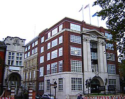
 The former Camberwell Town Hall | |
 The Borough of Camberwell within the County of London | |
| Area | |
| • 1911/1931 | 4,480 acres (18.1 km2)[1] |
| • 1961 | 4,482 acres (18.14 km2)[1] |
| Population | |
| • 1911 | 261,328[1] |
| • 1931 | 251,294[1] |
| • 1961 | 175,304[1] |
| Density | |
| • 1911 | 58/acre |
| • 1931 | 56/acre |
| • 1961 | 39/acre |
| History | |
| • Origin | Ancient parish |
| • Abolished | 1965 |
| • Succeeded by | London Borough of Southwark |
| Status | Civil parish (until 1965) Metropolitan borough (1900–1965) |
| Government | Camberwell Vestry (1674–1900, reformed 1855) Camberwell Borough Council (1900–1965) |
| • HQ | St Giles's Church (1674–1827) Vestry Hall, Havil Street (1827–1873) Vestry Hall, Peckham Road (1873–1934) Town Hall, Peckham Road (1934–1965) |
| • Motto | All's well |
 Coat of arms of the borough council | |
 Map of borough boundary Map of borough boundary | |
Camberwell was a civil parish and metropolitan borough in south London, England. Camberwell was an ancient parish in the county of Surrey, governed by an administrative vestry from 1674. The parish was included in the area of responsibility of the Metropolitan Board of Works in 1855 and became part of the County of London in 1889. The parish of Camberwell became a metropolitan borough in 1900, following the London Government Act 1899, with the parish vestry replaced by a borough council. In 1965 the borough was abolished and its former area became part of the London Borough of Southwark in Greater London.