Back ويرال Arabic Уиръл (община) Bulgarian Distrig Wirral Breton Metropolitan Borough of Wirral CEB Bwrdeistref Fetropolitan Cilgwri Welsh Metropolitan Borough of Wirral German Wirral Esperanto کلانشهر مستقل ویرال Persian District métropolitain de Wirral French Borgo metropolitano di Wirral Italian
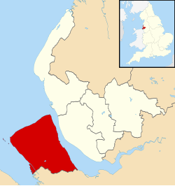
The Metropolitan Borough of Wirral is a metropolitan borough of Merseyside, in North West England. It has a population of 322,453 (2022),[3] and encompasses 62 square miles (161 km2) of the northern part of the Wirral Peninsula. Major settlements include Birkenhead, Wallasey, Bebington, Heswall, Hoylake and West Kirby. Wirral is England's westernmost metropolitan borough, faced by the city of Liverpool to the northeast over the River Mersey.
- ^ "Councillors and committees". Wirral Council. Retrieved 15 December 2023.
- ^ "Mid-Year Population Estimates, UK, June 2022". Office for National Statistics. 26 March 2024. Retrieved 3 May 2024.
- ^ a b "Mid-Year Population Estimates, UK, June 2022". Office for National Statistics. 26 March 2024. Retrieved 3 May 2024.
- ^ a b UK Census (2021). "2021 Census Area Profile – Wirral Local Authority (E08000015)". Nomis. Office for National Statistics. Retrieved 8 August 2023.


