Back نهر ميامي Arabic Riu Miami Catalan Miami River (suba sa Tinipong Bansa, Florida) CEB Miami River Danish Río Miami Spanish Miami River (Floride) French Miami (fiume) Italian Miami (rivier) Dutch Rio Miami Portuguese Майами (река, впадает в залив Бискейн) Russian
| Miami River | |
|---|---|
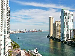
 The mouth of the Miami River at Brickell Key | |
 | |
| Location | |
| Country | United States |
| Physical characteristics | |
| Source | |
| • location | The Everglades |
| • elevation | Sea level |
| Mouth | |
• location | Brickell Point |
• coordinates | 25°46′14″N 80°11′06″W / 25.7705°N 80.1851°W |
| Length | 5.5 mi (8.9 km) |
| Basin size | 2,800 sq mi (7,300 km2) |
| Discharge | |
| • average | 50 cu ft/s (1.4 m3/s) |
The Miami River is a river in the U.S. state of Florida that drains out of the Everglades and runs through the city of Miami, including Downtown. The 5.5-mile (8.9 km) long river flows from the terminus of the Miami Canal at Miami International Airport to Biscayne Bay. It was originally a natural river inhabited at its mouth by the Tequesta Native Americans, but it was dredged and is now polluted throughout its route through Miami-Dade County. The mouth of the river is home to the Port of Miami and many other businesses whose pressure to maintain it has helped to improve the river's condition.