Back Mindanao Afrikaans مينداناو Arabic Mindanao AST Mindanao Azerbaijani Минданао (утрау) Bashkir Mindanao BCL Мінданаа (востраў) Byelorussian Мінданао (востраў) BE-X-OLD Минданао Bulgarian Mindanao BJN
Native name:
| |
|---|---|
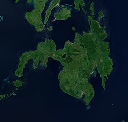
 Composite satellite image of Mindanao captured by Sentinel-2 in 2019 | |
| Geography | |
| Location | Philippines |
| Coordinates | 8°00′N 125°00′E / 8.000°N 125.000°E |
| Archipelago | Philippine |
| Adjacent to | |
| Major islands | |
| Area | 97,530 km2 (37,660 sq mi)[1] |
| Area rank | 19th |
| Highest elevation | 2,954 m (9692 ft) |
| Highest point | Mount Apo |
| Administration | |
| Regions | |
| Provinces | List |
| Largest settlement | Davao City (pop. 1,776,949) |
| Demographics | |
| Demonym |
|
| Population | 27,021,036 (2021) (Mindanao island group) [2] |
| Pop. density | 243/km2 (629/sq mi) |
| Ethnic groups | List |
Mindanao (/ˌmɪndəˈnaʊ/ MIN-də-NOW) is the second-largest island in the Philippines, after Luzon, and seventh-most populous island in the world. Located in the southern region of the archipelago, the island is part of an island group of the same name that also includes its adjacent islands, notably the Sulu Archipelago. According to the 2020 census, Mindanao had a population of 26,252,442, while the entire island group had an estimated population of 27,021,036.
Mindanao is divided into six administrative regions: the Zamboanga Peninsula, Northern Mindanao, the Caraga region, the Davao region, Soccsksargen, and the autonomous region of Bangsamoro. According to the 2020 census, Davao City is the most populous city on the island, with 1,776,949 people, followed by Zamboanga City (pop. 977,234), Cagayan de Oro (pop. 728,402), General Santos (pop. 697,315), Butuan (pop. 372,910), Iligan (pop. 363,115) and Cotabato City (pop. 325,079).[3] About 70% of residents identify as Christian and 24% as Muslim.[4][needs update] Mindanao is considered the major breadbasket of the Philippines.[5][6]
- ^ "Island Directory Tables". UN System-Wide Earthwatch Web Site. Archived from the original on December 1, 2015. Retrieved October 10, 2017.
- ^ "Population and Annual Growth Rates for The Philippines and Its Regions, Provinces, and Highly Urbanized Cities" (PDF). 2010 Census and Housing Population. National Statistics Office. Archived from the original (PDF) on September 28, 2013. Retrieved August 15, 2014.
- ^ "Population and Housing". Philippine Statistics Authority. Archived from the original on March 12, 2017. Retrieved March 15, 2017.
- ^ Cite error: The named reference
:1was invoked but never defined (see the help page). - ^ "Fruits of Peace". The Economist. October 15, 2015. Archived from the original on July 1, 2017. Retrieved October 10, 2017.
- ^ Calderon, Justin (April 22, 2013). "Unearthed Gem". Investvine. Archived from the original on December 26, 2018. Retrieved April 29, 2013.
