Back جزيرة مياكو Arabic مياكو (جزيره) ARZ Miyako adası Azerbaijani Miyako-jima CEB Miyako-jima German Mijako (insulo) Esperanto Isla Miyako Spanish میاکو-جیما Persian Miyako-jima French Pulau Miyako ID
Native name: Miyako-jima (宮古島) | |
|---|---|
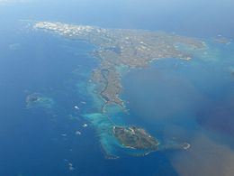
 Aerial view of Miyako Island from northwest | |
| Geography | |
| Location | Okinawa Prefecture |
| Coordinates | 24°46′N 125°19′E / 24.767°N 125.317°E |
| Archipelago | Miyako Islands |
| Adjacent to | East China Sea |
| Area | 158.87 km2 (61.34 sq mi)[1] |
| Highest elevation | 114.8 m (376.6 ft) |
| Highest point | Nakao (ナカオ嶺) |
| Administration | |
| Prefecture | Okinawa Prefecture |
| Demographics | |
| Population | 45,625 (2015 national census)[1] |
| Pop. density | 275.4/km2 (713.3/sq mi) |
| Ethnic groups | Ryukyuan, Japanese |
Miyako Island (宮古島, Miyako-jima, Miyako: Myaaku (ミャーク); Okinawan: Naaku (ナーク)) is the largest and the most populous island among the Miyako Islands of Okinawa Prefecture, Japan. Miyako Island is administered as part of the City of Miyakojima, which includes not only Miyako Island, but also five other islands.[2]


