Back Monterey County Afrikaans مقاطعة مونتيري (كاليفورنيا) Arabic Monterey qraflığı (Kaliforniya) Azerbaijani Monterey County, Kalifornien BAR Мантэрэй (акруга) Byelorussian Монтерей (окръг, Калифорния) Bulgarian মোন্টোরি কাউন্টি, ক্যালিফোর্নিয়া BPY Comtat de Monterey Catalan Монтерей (гуо, Калифорни) CE Monterey County CEB
Monterey County, California | |
|---|---|
| County of Monterey | |
|
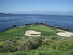
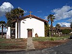
Images, from top down, left to right: Monterey Bay Aquarium, Main Street in Salinas, the seventh hole at Pebble Beach Golf Links, Mission Soledad, Big Sur Coastline | |
 Interactive map of Monterey County | |
 Location in the state of California | |
| Country | United States |
| State | California |
| Incorporated | February 18, 1850[1] |
| Named for | Monterey Bay |
| County seat | Salinas |
| Largest city | Salinas |
| Government | |
| • Type | Council–CAO |
| • Body | Board of Supervisors |
| • Chair | Luis Alejo |
| • Vice Chair | Glenn Church |
| • Board of Supervisors[2] | Supervisors
|
| • County Administrative Office | Sonia M. De La Rosa |
| Area | |
• Total | 3,771 sq mi (9,770 km2) |
| • Land | 3,281 sq mi (8,500 km2) |
| • Water | 491 sq mi (1,270 km2) |
| Highest elevation | 5,865 ft (1,788 m) |
| Population (2020) | |
• Total | 439,035 |
| • Density | 134/sq mi (52/km2) |
| GDP | |
| • Total | $33.249 billion (2022) |
| Time zone | UTC-8 (Pacific Time Zone) |
| • Summer (DST) | UTC-7 (Pacific Daylight Time) |
| Area codes | 805, 831 |
| Congressional districts | 18th, 19th |
| Website | countyofmonterey |
Monterey County (/ˌmɒntəˈreɪ/ MON-tə-RAY), officially the County of Monterey, is a county located on the Pacific coast in the U.S. state of California. As of the 2020 census, its population was 439,035.[5] The county's largest city and county seat is Salinas.[6]
Monterey County comprises the Salinas, California, Metropolitan Statistical Area. It borders on the southern part of Monterey Bay, after which it is named. (The northern half of the bay is in Santa Cruz County.) Monterey County is a member of the regional governmental agency: the Association of Monterey Bay Area Governments.
Scenic features along the coastline - including Carmel-by-the-Sea, Big Sur, State Route 1, and the 17 Mile Drive on the Monterey Peninsula - have made the county famous around the world. Back when California was under Spanish and Mexican rule, the city of Monterey was its capital. Today, the economy of the county is mostly based on tourism in its coastal regions, and on agriculture in the region of the Salinas River valley. Most of the county's inhabitants live near the northern coast or in Salinas Valley; the southern coast and inland mountainous regions are sparsely populated.
- ^ "Chronology". California State Association of Counties. Retrieved February 6, 2015.
- ^ "Board of Supervisors | Monterey County, CA".
- ^ "Junipero Serra Peak". Peakbagger.com. Retrieved March 16, 2015.
- ^ "Gross Domestic Product: All Industries in Monterey County, CA". Federal Reserve Economic Data. Federal Reserve Bank of St. Louis.
- ^ "Monterey County, California". United States Census Bureau. Retrieved January 30, 2022.
- ^ "Find a County". National Association of Counties. Retrieved June 7, 2011.


