Back Muntgumnisċīr ANG Монтгомъришър Bulgarian Sir Drefaldwyn Breton Sir Drefaldwyn Welsh Montgomeryshire German Montgomeryshire Spanish Montgomeryshire French Montgomeryshire FRR Sir Drefaldwyn Irish Montgomeryshire Italian
| Montgomeryshire Sir Drefaldwyn (Welsh) | |
|---|---|
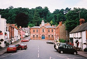
 Broad Street and Montgomery Town Hall (2001) | |
| Area | |
| • 1831 | 483,323 acres (1,955.94 km2) |
| Population | |
| • 1831 | 66,482[1] |
| Density | |
| • 1831 | 0.1/acre |
| History | |
| • Succeeded by | Powys |
| Chapman code | MGY |
| Government | Montgomeryshire County Council (1889–1974) Montgomeryshire District Council (1974–1996) |
| • HQ | Montgomery |
Until 1974, Montgomeryshire (Welsh: Sir Drefaldwyn meaning "the Shire of Baldwin's town") was an administrative county in mid Wales, later classed as one of the thirteen historic counties of Wales. It was named after its county town, Montgomery, which in turn was named after one of William the Conqueror's main counsellors, Roger de Montgomerie, who was the 1st Earl of Shrewsbury.
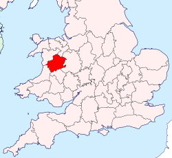
The area of what was Montgomeryshire, now constitutes the northern part of the principal area of Powys. The current area was 2,174 square km (839 square miles).
The largest town was Newtown, followed by Welshpool and Llanidloes.
- ^ Vision of Britain – 1831 Census


