Back نهر موس (نهر) ARZ Мус (река) Bulgarian Moose River (suba sa Kanada, Ontario, lat 51,33, long -80,40) CEB Moose Czech Moose River (James Bay) German Río Moose (Ontario) Spanish Rivière Moose (Ontario) French Moose (fiume) Italian ムース川 Japanese Мус Kazakh
| Moose River | |
|---|---|
 Moose River as seen from the ONR railway bridge | |
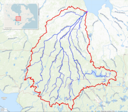
 Moose River basin map | |
| Location | |
| Country | Canada |
| Province | Ontario |
| District | Cochrane |
| Physical characteristics | |
| Source confluence | Mattagami and Missinaibi Rivers |
| • location | Unnamed wilderness of Unorg. Cochrane District |
| • coordinates | 50°44′08″N 81°28′02″W / 50.73556°N 81.46722°W |
| Mouth | James Bay |
• location | 17 km NE from Moosonee |
• coordinates | 51°21′02″N 80°23′57″W / 51.35056°N 80.39917°W |
| Length | 104 km (65 mi)[1] |
| Basin size | 108,500 km2 (41,900 sq mi)[1] |
| Discharge | |
| • average | 1,370 m3/s (48,000 cu ft/s)[1] |
The Moose River is a river in the Hudson Plains ecozone of northern Ontario, Canada. The river flows 100 km northeast from the confluence of the Mattagami and Missinaibi Rivers into James Bay. Its drainage basin is 108,500 square kilometres (41,900 sq mi) and it has a mean discharge rate of 1,370 cubic metres (48,000 cu ft). Its full length is 547 kilometres (340 mi) if counted from the head of the Mattagami River.[1]
This river formed part of the water route to Lake Superior in the days of the fur trade. Moose Factory, located on Moose Factory Island near the river's mouth, was a fur trading post of the Hudson's Bay Company and Ontario's first English settlement. Moosonee, on the north bank of the river, is the northern terminus of the Polar Bear Express railway route which begins at Cochrane, Ontario.
- ^ a b c d Atlas of Canada
