| Mount Blue State Park | |
|---|---|
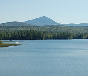
 Webb Lake and Mount Blue | |
| Location | Weld, Maine, United States |
| Coordinates | 44°43′41″N 70°20′31″W / 44.72806°N 70.34194°W[1] |
| Area | 7,489 acres (30.31 km2)[2] |
| Elevation | 3,183 ft (970 m)[1] |
| Established | 1955 |
| Administrator | Maine Department of Agriculture, Conservation and Forestry |
| Website | Mount Blue State Park |
Mount Blue State Park is a public recreation area covering 7,489 acres (3,031 ha) in the town of Weld, Franklin County, Maine.[3] The state park's bifurcated land includes acreage on the west shore of Webb Lake as well as Mount Blue and other peaks to the east of the lake. The park is connected by road with the 10,555-acre (4,271 ha)[2] Tumbledown Public Lands, the site of Little Jackson Mountain, Tumbledown Mountain, and Tumbledown Pond, an alpine lake near the top of Tumbledown and Little Jackson mountains.[4] The park and public lands are managed by the Maine Department of Agriculture, Conservation and Forestry.
- ^ a b "Mount Blue". Geographic Names Information System. United States Geological Survey, United States Department of the Interior.
- ^ a b Cite error: The named reference
dacf2was invoked but never defined (see the help page). - ^ Cite error: The named reference
dacfwas invoked but never defined (see the help page). - ^ Cite error: The named reference
dacf4was invoked but never defined (see the help page).

