Back Kenia (berg) Afrikaans جبل كينيا Arabic Monte Kenia AST Kenėjės kalns BAT-SMG Bukid Kenya BCL Кенія (гара) Byelorussian Кенія (гара) BE-X-OLD Кения (планина) Bulgarian কেনিয়া পর্বত Bengali/Bangla Menez Kenya Breton
| Mount Kenya | |
|---|---|
 | |
| Highest point | |
| Elevation | 5,199 m (17,057 ft)[1] |
| Prominence | 3,825 m (12,549 ft)[1] Ranked 32nd |
| Listing | Seven Second Summits Country high point Ultra |
| Coordinates | 0°9′03″S 37°18′27″E / 0.15083°S 37.30750°E[1] |
| Naming | |
| Native name | |
| Geography | |
| Topo map(s) | Mount Kenya by Wielochowski and Savage[2][3] |
| Geology | |
| Mountain type | Stratovolcano (extinct) |
| Last eruption | 2.6–3.1 MYA |
| Climbing | |
| First ascent | 13 September 1899 by Mackinder, Ollier, and Brocherel, although the peoples of Kenya believed God (Ngai in Gikuyu) resided on this mountain and regularly ascended the peaks to perform spiritual rites.[4] |
| Easiest route | Rock climb |
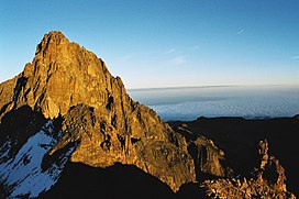
Mount Kenya (Meru: Kĩrĩmaara, Kikuyu: Kĩrĩnyaga, Kamba: Ki nyaaa, Embu: Kirinyaa) is an extinct volcano in Kenya and the second-highest peak in Africa, after Kilimanjaro.[5] The highest peaks of the mountain are Batian (5,199 metres (17,057 feet)), Nelion (5,188 m (17,021 ft)) and Point Lenana (4,985 m (16,355 ft)). Mount Kenya is located in the former Eastern and Central provinces of Kenya; its peak is now the intersection of Meru, Embu, Kirinyaga, Nyeri and Tharaka Nithi counties, about 16.5 kilometres (10.3 miles) south of the equator, around 150 km (90 mi) north-northeast of the capital Nairobi.[6][5] Mount Kenya is the source of the name of the Republic of Kenya.
Mount Kenya is a volcano created approximately 3 million years after the opening of the East African Rift.[7] Before glaciation, it was 7,000 m (23,000 ft) high. It was covered by an ice cap for thousands of years. This has resulted in very eroded slopes and numerous valleys radiating from the peak.[8][9] There are currently 11 small glaciers, which are shrinking rapidly, and may disappear by 2050.[10] The forested slopes are an important source of water for much of Kenya.[11]
There are several vegetation bands from the base to the peak.[12] The lower slopes are covered by different types of forest. Many alpine species are endemic to Mount Kenya, such as the giant lobelias and senecios and a local subspecies of rock hyrax.[13] An area of 715 km2 (276 sq mi) around the centre of the mountain was designated a National Park and listed as a UNESCO World Heritage Site in 1997.[14] The park receives over 16,000 visitors per year.[15][11]
- ^ a b c "Africa Ultra-Prominences" Peaklist.org. Retrieved 6 February 2012.
- ^ Cite error: The named reference
ewp_kenya_mapwas invoked but never defined (see the help page). - ^ Cite error: The named reference
mapwas invoked but never defined (see the help page). - ^ Cite error: The named reference
facingmtkenyawas invoked but never defined (see the help page). - ^ a b Cite error: The named reference
rough_guidewas invoked but never defined (see the help page). - ^ "Where is Mount Kenya Located?". WorldAtlas. 8 June 2018.
- ^ Philippe Nonnotte. "Étude volcano-tectonique de la zone de divergence Nord-Tanzanienne (terminaison sud du rift kenyan) – Caractérisation pétrologique et géochimique du volcanisme récent (8 Ma – Actuel) et du manteau source – Contraintes de mise en place thèse de doctorat de l'université de Bretagne occidentale, spécialité : géosciences marines" (PDF).
- ^ Cite error: The named reference
gregory1894was invoked but never defined (see the help page). - ^ Cite error: The named reference
bakerwas invoked but never defined (see the help page). - ^ TravelMedals (26 January 2020). "Mount Kenya Summit Challenge!". Travel Medals. Retrieved 26 May 2020.
- ^ a b Cite error: The named reference
developmentwas invoked but never defined (see the help page). - ^ Resnick, Mike (1998). Kirinyaga: a fable of Utopia. Ballantine. p. 293. ISBN 978-0-345-41701-5.
- ^ Coe, Malcolm James (1967). The Ecology of the Alpine Zone of Mount Kenya. The Hague: Dr W. Junk.
- ^ Cite error: The named reference
unescowas invoked but never defined (see the help page). - ^ "World Heritage Nomination – IUCN Technical Evaluation Mount Kenya (Kenya)" (PDF).
