Back جبل المشارف Arabic جبل المشارف ARZ Скопий Bulgarian Muntanya Scopus Catalan Mount Scopus CEB Skopus Czech Mt. Scopus Danish Skopus (Berg) German Όρος Σκοπός Greek Monto Skopus Esperanto
| Mount Scopus | |
|---|---|
| הַר הַצּוֹפִים Har HaTsofim جبل المشارف Ǧabal al-Mašārif | |
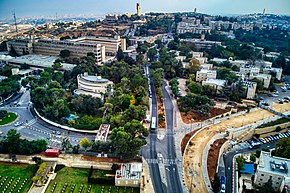
 The Hebrew University campus and tower on Mount Scopus from the north | |
| Highest point | |
| Elevation | 826 m (2,710 ft) |
| Coordinates | 31°47′33″N 35°14′39″E / 31.79250°N 35.24417°E |
| Geography | |
 | |
| Location | Jerusalem |
| Parent range | Judaean |


| Part of a series on |
| Jerusalem |
|---|
 |
Mount Scopus (Hebrew: הַר הַצּוֹפִים Har HaTsofim, "Mount of the Watchmen/ Sentinels"; Arabic: جبل المشارف Ǧabal al-Mašārif, lit. "Mount Lookout", or جبل المشهد Ǧabal al-Mašhad "Mount of the Scene/Burial Site", or جبل الصوانة "Mount Syenite") is a mountain (elevation: 826 meters (2,710 ft) above sea level) in northeast Jerusalem.
Between the 1948 Arab–Israeli War and the Six-Day War in 1967, the peak of Mount Scopus with the Hebrew University campus and Hadassah Hospital was a UN-protected exclave of Israel within Jordan. Today, Mount Scopus lies within the municipal boundaries of the city of Jerusalem.