Back مايتمرويد ARZ Mytholmroyd CEB Mytholmroyd Welsh Mytholmroyd German Mytholmroyd Spanish مایتمروید Persian Mytholmroyd French Mytholmroyd Frisian Mytholmroyd Irish Mytholmroyd Italian
This article needs additional citations for verification. (June 2020) |
| Mytholmroyd | |
|---|---|
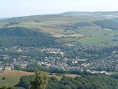
 View of Mytholmroyd from the north | |
Location within West Yorkshire | |
| Population | 3,949 (2011)[1] |
| OS grid reference | SE012260 |
| Civil parish | |
| Metropolitan borough | |
| Metropolitan county | |
| Region | |
| Country | England |
| Sovereign state | United Kingdom |
| Post town | HEBDEN BRIDGE |
| Postcode district | HX7 |
| Dialling code | 01422 |
| Police | West Yorkshire |
| Fire | West Yorkshire |
| Ambulance | Yorkshire |
| UK Parliament | |
Mytholmroyd (pronounced /ˈmaɪðəmrɔɪd/) is a large village and former civil parish, now in the parish of Hebden Royd, in the Calderdale district, in West Yorkshire, England, 2 miles (3 km) east of Hebden Bridge. It lies in the Upper Calder Valley, 10 miles (16 km) east of Burnley and 7 miles (11 km) west of Halifax. The village, which has a population of approximately 4,000, is in the Luddendenfoot Ward of Calderdale Council.[2]
The village holds regular markets. Mytholmroyd has business parks and a high street in the centre with many independent shops. It now is a designated conservation area,[3] with more than 21 listed buildings in the village.
- ^ "Mytholmroyd (West Yorkshire, Yorkshire and the Humber, United Kingdom) - Population Statistics and Location in Maps and Charts". CityPopulation.de. Retrieved 5 February 2017.
- ^ "Hebden Royd Council". 2017. Archived from the original on 29 June 2017. Retrieved 1 January 2017.
- ^ "Mytholmroyd, Hebden Royd - Calderdale | Historic England". historicengland.org.uk. Retrieved 16 April 2023.

