Back النبي صموئيل Arabic النبى صموئيل ARZ Nabi Samwil Catalan An Nabī Şamū'īl CEB Deir an-Nabi Samwīl German النبی ساموئل Persian Nebi Samwil French נבי סמואל HE Nabi Samwil ID Nabi Samwil Italian
an-Nabi Samwil | |
|---|---|
| Arabic transcription(s) | |
| • Arabic | النبي صموئيل |
| • Latin | an-Nebi Samwil (official) an-Nabi Samuil (unofficial) |
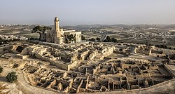
 Aerial view | |
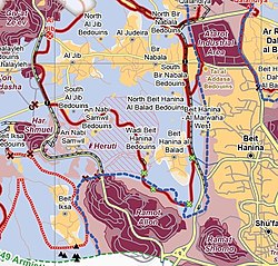
 Nabi Samwil shown within the Area C "National Park" (hashed area) | |
Location of an-Nabi Samwil within Palestine | |
| Coordinates: 31°49′58″N 35°10′49″E / 31.83278°N 35.18028°E | |
| Palestine grid | 167/137 |
| State | State of Palestine |
| Governorate | Jerusalem |
| Government | |
| • Type | Local Development Committee |
| Area | |
| • Total | 1,592 dunams (1.6 km2 or 0.6 sq mi) |
| Highest elevation | 908 m (2,979 ft) |
| Population (2017)[1] | |
| • Total | 234 |
| • Density | 150/km2 (380/sq mi) |
| Name meaning | "the prophet Samuel"[2] |
An-Nabi Samwil, also called al-Nabi Samuil (Arabic: النبي صموئيل an-Nabi Samu'il, translit: "the prophet Samuel"), is a Palestinian village in the Quds Governorate of the State of Palestine, located in the West Bank (Area C), four kilometers north of Jerusalem. The village is built up around the Mosque of Nabi Samwil, containing the Tomb of Samuel; the village's Palestinian population has since been removed by the Israeli authorities from the village houses to a new location slightly down the hill. The village had a population of 234 in 2017.[1]
A tradition dating back to the Byzantine period places here the tomb of Prophet Samuel. In the 6th century, a monastery was built at the site in honor of Samuel, and during the early Arab period the place was known as Dir Samwil (the Samuel Monastery).[3] In the 12th century, during the Crusader period, a fortress was built on the area.[3] In the 14th century, during the Mameluk period, a mosque was built over the ruins of the Crusader fortress.[3] The purported tomb itself is in an underground chamber of the mosque, which has been repurposed after 1967 as a synagogue, today with separate prayer areas for Jewish men and women.
- ^ a b Preliminary Results of the Population, Housing and Establishments Census, 2017 (PDF). Palestinian Central Bureau of Statistics (PCBS) (Report). State of Palestine. February 2018. pp. 64–82. Retrieved 2023-10-24.
- ^ Palmer, 1881, p. 324
- ^ a b c "Nebi Samuel Park – Israel Nature and Parks Authority". en.parks.org.il. Archived from the original on 2022-03-12. Retrieved 2022-06-03.
