Back Prefektur Nagasaki ACE Nagasaki-prefektuur Afrikaans ناغاساكي (محافظة) Arabic Naqasaki prefekturası Azerbaijani ناقاساکی اوستانی AZB Нагасаки (префектура) Bashkir Préféktur Nagasaki BAN Nagasakė prefektūra BAT-SMG Нагасакі (прэфектура) Byelorussian Нагасаки (префектура) Bulgarian
Nagasaki Prefecture
長崎県 | |
|---|---|
| Japanese transcription(s) | |
| • Japanese | 長崎県 |
| • Rōmaji | Nagasaki-ken |
 Obon Festival with tōrō nagashi lantern release on the Albuquerque Bridge over the Sasebo River, Sasebo City, Nagasaki Prefecture | |
| Anthem: Minami no kaze | |
 | |
| Coordinates: 32°45′00″N 129°52′03″E / 32.75000°N 129.86750°E | |
| Country | |
| Region | Kyushu |
| Island | Kyushu |
| Capital | Nagasaki |
| Subdivisions | Districts: 4, Municipalities: 21 |
| Government | |
| • Governor | Kengo Oishi since 2 March 2022 |
| Area | |
| • Total | 4,130.88 km2 (1,594.94 sq mi) |
| • Rank | 37th |
| Population (June 1, 2020) | |
| • Total | 1,314,078 |
| • Rank | 27th |
| • Density | 320/km2 (820/sq mi) |
| • Dialects | Nagasaki・Tsushima |
| GDP | |
| • Total | JP¥4,800 billion US$43.9 billion (2019) |
| ISO 3166 code | JP-42 |
| Website | www |
| Symbols of Japan | |
| Bird | Mandarin duck (Aix galericulata) |
| Flower | Unzentsutsuji (Rhododendron serpyllifolium) |
| Tree | Sawara (Chamaecyparis pisifera) |
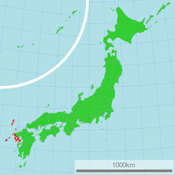
Nagasaki Prefecture (長崎県, Nagasaki-ken) is a prefecture of Japan, mainly located on the island of Kyūshū, although it also includes a number of islands off Kyūshū's northwest coast - including Tsushima and Iki. Nagasaki Prefecture has a population of 1,314,078 (1 June 2020) and has a geographic area of 4,130 km2 (1,594 sq mi). Nagasaki Prefecture borders Saga Prefecture to the northeast.
Nagasaki is the capital and largest city of Nagasaki Prefecture, with other major cities including Sasebo, Isahaya, and Ōmura. Nagasaki Prefecture is located in western Kyūshū with a territory consisting of many mainland peninsulas centered around Ōmura Bay, as well as islands and archipelagos including Tsushima and Iki in the Korea Strait and the Gotō Islands in the East China Sea. Nagasaki Prefecture is known for its century-long trading history with the Europeans and as the sole place of direct trade and exchange between Japan and the outside world during the Sakoku period. Nagasaki Prefecture is home to several of the Hidden Christian Sites in the Nagasaki Region which have been declared a UNESCO World Heritage Site.
- ^ "2020年度国民経済計算(2015年基準・2008SNA) : 経済社会総合研究所 - 内閣府". 内閣府ホームページ (in Japanese). Retrieved 2023-05-18.

