Back نالاندا ديستريكت ARZ नालंदा जिला AWA नालंदा जिला Bihari নালন্দা জেলা Bengali/Bangla Nalanda (Distrikt) German Distrito de Nalanda Spanish Nalanda barrutia Basque بخش نالاندا Persian District de Nalanda French નાલંદા જિલ્લો Gujarati
Nalanda district | |
|---|---|
 Location of Nalanda district in Bihar | |
| Country | |
| State | |
| Division | Patna |
| Established | 9 November 1972 |
| Headquarters | Bihar Sharif |
| Government | |
| • Lok Sabha constituencies | Nalanda |
| Area | |
• Total | 2,367 km2 (914 sq mi) |
| • Urban | 112.91 km2 (43.59 sq mi) |
| Population (2011) | |
• Total | 2,877,653 |
| • Density | 1,200/km2 (3,100/sq mi) |
| Demographics | |
| • Literacy | 66.41 (M=77.11; F=54.76) |
| • Sex ratio | 921 (2011) |
| Time zone | UTC+05:30 (IST) |
| PIN Code | 803111[1] |
| Major highways | NH 20, NH 33, NH 120, NH 431 |
| Website | Nalanda District |

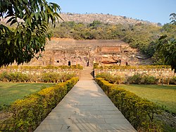
Nalanda district is one of the thirty-eight districts of the state of Bihar in India. Bihar Sharif is the administrative headquarters of this district. The districts is home to the ancient Nalanda Mahavihara a UNESCO World Heritage Site. Nalanda is located in the Magadh region of southern Bihar.[2]
- ^ "NALANDA Pin Code - 803111, Silao All Post Office Areas PIN Codes, Search NALANDA Post Office Address". ABP Live. Retrieved 28 July 2022.
- ^ Chaudhary, Pranava Kumar (15 July 2016). "UNESCO declares Nalanda Mahavihara World Heritage Site". The Times of India. Retrieved 3 January 2021.

