Back National Highway 4 (Indien) German રાષ્ટ્રીય ધોરીમાર્ગ 4 (ભારત) Gujarati राष्ट्रीय राजमार्ग ४ (भारत, पुराना संख्यांक) Hindi ദേശീയപാത 4 (ഇന്ത്യ) Malayalam राष्ट्रीय महामार्ग ४ (जुने क्रमांकन) Marathi ਨੈਸ਼ਨਲ ਹਾਈਵੇ 4 (ਭਾਰਤ) Punjabi نیشنل ہائیوے 4 (بھارت) PNB தேசிய நெடுஞ்சாலை 4 (இந்தியா) Tamil
| NH4 (India, old numbering) | ||||
|---|---|---|---|---|
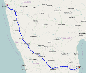
 Road map of India with National Highway 4 (pre 2010) highlighted in solid blue colour | ||||
| Route information | ||||
| Part of | ||||
| Length | 1,235 km (767 mi) | |||
| Time period | Pre 2010 | |||
| Major junctions | ||||
| From | Mumbai, Maharashtra | |||
List
| ||||
| To | Chennai, Tamil Nadu | |||
| Location | ||||
| Country | India | |||
| States | Maharashtra: 371 km (231 mi) Karnataka: 658 km (409 mi) Andhra Pradesh: 83 km (52 mi) Tamil Nadu: 133 km (83 mi) | |||
| Primary destinations | Mumbai - Thane - Panvel - Pune - Satara - Karad - Uran Islampur - Kolhapur - Belagavi - Dharwad - Hubli - Haveri - Ranebennur - Davangere - Chitradurga - Sira - Tumkur - Bangalore - Kolar - Chittoor - Thiruvalam - Ranipet - Walajapet - Sriperumbudur - Chennai | |||
| Highway system | ||||
| ||||
National Highway 4 (NH 4) was a major National Highway before National Highway renumbering in Western and Southern India. NH 4 linked four of the 10 most populous Indian cities – Mumbai, Pune, Bangalore, and Chennai. NH 4 was 1,235 km (767 mi) in length and passed through the states of Maharashtra, Karnataka and Tamil Nadu.[1] It is now numbered as National Highway 48 (India). National Highway 4 was known as P.B.Road (Pune-Bangalore Road) in many parts of Maharashtra and Karnataka states before it was renumbered.
- ^ http://www.nhai.org/NH4_Mumbai_Chennai_english.htm Map of NH4 from the National Highways Authority of India