Back Rehiyon kan Isla kan Negros BCL Negros Island Region German Región de Negros Spanish Rehion ti Isla ti Negros ILO ネグロス島地方 Japanese 네그로스섬 지방 Korean Negros LAD Negros Island Region NB Negros PAM Negros Island Region Swedish
Negros Island Region | |
|---|---|
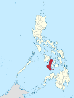
 Location within the Philippines | |
| Country | |
| Island group | Visayas |
| Establishment | May 29, 2015 (first iteration) June 11, 2024 (second iteration) |
| Regional centers | Bacolod and Dumaguete (interim/de facto) |
| Largest city | Bacolod |
| Area | |
| • Total | 13,525.56 km2 (5,222.25 sq mi) |
| Highest elevation | 2,465 m (8,087 ft) |
| Population (2020 census)[1] | |
| • Total | 4,760,340 |
| • Density | 350/km2 (910/sq mi) |
| Time zone | UTC+8 (PST) |
| Provinces | |
| Independent cities | 1 |
| Component cities | |
| Municipalities | 44 |
| Barangays | 1,353 |
| Languages | |
| GDP (2022 estimate) | ₱557.68 billion $9.5 billion |
The Negros Island Region (NIR)[2] is an administrative region in the Philippines. Covering both the islands of Negros and Siquijor, the region is composed of three provinces: Negros Occidental, Negros Oriental, and Siquijor, as well as the highly urbanized city of Bacolod. The regional centers are Bacolod and Dumaguete.
The first iteration of the region existed from May 29, 2015, to August 9, 2017, and comprised the provinces of Negros Occidental and Negros Oriental and the city of Bacolod, all of which are situated on the island of Negros. After nearly seven years, the region was re-established on June 11, 2024, this time with the inclusion of Siquijor, an island province located southeast of Negros that was formerly part of Central Visayas.[2][3]
- ^ Census of Population (2020). Table B - Population and Annual Growth Rates by Province, City, and Municipality - By Region. Philippine Statistics Authority. Retrieved July 8, 2021.
- ^ a b Republic Act No. 12000 (June 11, 2024), An Act Establishing the Negros Island Region (PDF), Official Gazette (Philippines), retrieved June 19, 2024.
- ^ Cite error: The named reference
marcossignswas invoked but never defined (see the help page).


