Back Neresheim ALS نيرسهايم Arabic نرزهایم AZB Нересхайм CE Neresheim (munisipyo) CEB Neresheim German Neresheim Esperanto Neresheimi vald Estonian Neresheim Basque نرزهایم Persian
You can help expand this article with text translated from the corresponding article in German. (February 2009) Click [show] for important translation instructions.
|
Neresheim | |
|---|---|
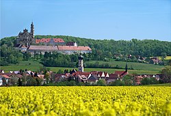
 Neresheim, abbey in background | |
Location of Neresheim within Ostalbkreis district  | |
| Coordinates: 48°45′15″N 10°20′04″E / 48.75417°N 10.33444°E | |
| Country | Germany |
| State | Baden-Württemberg |
| Admin. region | Stuttgart |
| District | Ostalbkreis |
| Subdivisions | 6 Stadtteile |
| Government | |
| • Mayor (2017–25) | Thomas Häfele[1] |
| Area | |
| • Total | 118.52 km2 (45.76 sq mi) |
| Elevation | 503 m (1,650 ft) |
| Population (2022-12-31)[2] | |
| • Total | 8,064 |
| • Density | 68/km2 (180/sq mi) |
| Time zone | UTC+01:00 (CET) |
| • Summer (DST) | UTC+02:00 (CEST) |
| Postal codes | 73450 |
| Dialling codes | 07326, Elchingen 07367 |
| Vehicle registration | AA |
| Website | www.neresheim.de |
Neresheim is a town in the Ostalbkreis district, in Baden-Württemberg, Germany. It is situated 16 kilometres (9.9 mi) northeast of Heidenheim, and 20 kilometres (12 mi) southeast of Aalen. It's the home of the Neresheim Abbey, which still hosts monks, was Reichsfrei until the German Mediatisation and was built by Balthasar Neumann. Another notable touristic attraction is the heritage railway Härtsfeldbahn.
Neresheim is listed on the Arc de Triomphe in Paris, France, along with 95 other sites of battles won by the French army.[3]


- ^ Aktuelle Wahlergebnisse, Staatsanzeiger, accessed 13 September 2021.
- ^ "Bevölkerung nach Nationalität und Geschlecht am 31. Dezember 2022" [Population by nationality and sex as of December 31, 2022] (CSV) (in German). Statistisches Landesamt Baden-Württemberg. June 2023.
- ^ Arc de Triomphe Archived 2005-03-06 at the Wayback Machine on Parisrama.com


