Back منطقة نغورونغورو المحمية Arabic Zona de caltenimientu de Ngorongoro AST Videxo ke Ngorongoro AVK Nqoronqoro Azerbaijani Нгорангора Byelorussian Нгоронгоро Bulgarian Zona de conservació de l'Ngorongoro Catalan Ngorongoro (reserbasyon sa kinaiyahan) CEB Ngorongoro Czech Ngorongoro Danish
| Ngorongoro Conservation Area | |
|---|---|
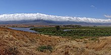
 View of the crater | |
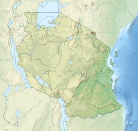
| Location | Ngorongoro District, Arusha Region, Tanzania |
| Coordinates | 03°12′36″S 35°27′36″E / 3.21000°S 35.46000°E |
| Area | 8,292 km2 (3,202 sq mi)[1] |
| Established | 1959 |
| Visitors | Over 500,000 per year[2] |
| Governing body | Ngorongoro Conservation Area Authority |
| Type | Mixed |
| Criteria | (iv)(vii)(viii)(ix)(x) |
| Designated | 1979 (3rd session) |
| Reference no. | 39 |
| Region | Africa |
| Endangered | 1984–1989 |

Ngorongoro Conservation Area (UK: /(ə)ŋˌɡɔːrəŋˈɡɔːroʊ/,[3] US: /ɛŋˌɡɔːroʊŋˈɡɔːroʊ, əŋˌɡoʊrɔːŋˈɡoʊroʊ/[4][5]) is a protected area and a UNESCO World Heritage Site located in Ngorongoro District, 180 km (110 mi) west of Arusha City in Arusha Region, within the Crater Highlands geological area of northeastern Tanzania. The area is named after Ngorongoro Crater, a large volcanic caldera within the area. The Ngorongoro Conservation Area Authority administers the conservation area, an arm of the Tanzanian government, and its boundaries follow the boundary of the Ngorongoro District in Arusha Region. The western portion of the park abuts the Serengeti National Park, and the area comprising the two parks and Kenya's Maasai Mara game reserve is home to Great Migration, a massive annual migration of millions of wildebeest, zebras, gazelles, and other animals. The conservation area also contains Olduvai Gorge, one of the most important paleoanthropological sites in the world.
The 2009 Ngorongoro Wildlife Conservation Act placed new restrictions on human settlement and subsistence farming in the Crater, displacing Maasai pastoralists, most of whom had been relocated to Ngorongoro from their ancestral lands [disputed – discuss] to the north when the British colonial government established Serengeti National Park in 1959.[6][7]
- ^ "The historical ecology of the large mammal populations of Ngorongoro Crater, Tanzania, east Africa", Mammal Review, authored by Louise Oates and Paul A. Rees, 2012
- ^ "Dar registers "three wonders"". Daily News (Tanzania). 20 August 2012. Archived from the original on 22 September 2012. Retrieved 28 January 2013.
- ^ "Ngorongoro". Lexico UK English Dictionary. Oxford University Press. Archived from the original on 22 March 2020.
- ^ "Ngorongoro Crater". The American Heritage Dictionary of the English Language (5th ed.). HarperCollins. Retrieved 2 August 2019.
- ^ "Ngorongoro Crater". Merriam-Webster.com Dictionary. Merriam-Webster. Retrieved 2 August 2019.
- ^ 'Tourism is a curse to us', Guardian, 6 September 2009
- ^ Laltaika, Elifuraha (2013). "Pastoralists' Right to Land and Natural Resources in Tanzania" (PDF). Oregon Review of International Law. 15 (1): 43–62. ISSN 1543-9860. Retrieved 12 June 2017.
