Back Niassa Afrikaans محافظة نياسا Arabic MozambikaNiassaWinka AVK Ньяса (правінцыя) BE-X-OLD Няса Bulgarian Província de Niassa Catalan Niassa Province CEB Niassa (provins) Danish Provinz Niassa German Επαρχία Νιάσα Greek
13°15′S 36°30′E / 13.250°S 36.500°E
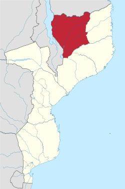
Niassa [ˈnjasɐ] is a province of Mozambique with an area of 129,056 km2 and a population of 1,810,794 (2017).[1] It is the most sparsely populated province in the country.[2] Lichinga is the capital of the province. There are a minimum estimated 450,000 Yao people living in Mozambique. They largely occupy the eastern and northern part of the Niassa province and form about 40% of the population of Lichinga, the capital of this province.
Niassa
Jimbo la Niassa (Swahili) | |
|---|---|
 | |
 Niassa, Province of Mozambique | |
| Country | Mozambique |
| Capital | Lichinga |
| Area | |
| • Total | 129,056 km2 (49,829 sq mi) |
| Highest elevation | 1,836 m (6,024 ft) |
| Population (2017 census) | |
| • Total | 1,810,794 |
| • Density | 14/km2 (36/sq mi) |
| Postal code | 33xx |
| Area code | (+258) 271 |
| HDI (2019) | 0.425[3] low · 8th of 11 |
| Website | www |

The Ruvuma River forms much of the northern boundary of the province with Ruvuma Region, Tanzania, while Lake Niassa forms the western border of the province, separating it from Malawi. 75% of the province remains untouched by development, and remains free of landmines.[2] The province shares the Niassa National Reserve with neighboring Cabo Delgado Province.[4]
- ^ "Total Population By Provinces - 2006". Instituto Nacional de Estatística. Archived from the original on November 24, 2007. Retrieved 2008-06-15.
- ^ a b "Niassa". Archived from the original on 2009-04-08. Retrieved 2009-12-31.
- ^ "Sub-national HDI - Area Database - Global Data Lab". hdi.globaldatalab.org. Retrieved 2018-09-13.
- ^ "The Lions of Niassa". Fauna and Flora International. 2009. Archived from the original on November 3, 2009. Retrieved 2009-12-31.