Back نهر نيدا (نهر) ARZ Ніда (рака) Byelorussian Nida (suba sa Polskowa, Województwo Świętokrzyskie, lat 50,30, long 20,85) CEB Nida (flod) Danish Nida (Fluss) German Νίντα (ποταμός) Greek Río Nida Spanish Nida jõgi Estonian Nida (ibaia) Basque Nida (rivière) French
| Nida | |
|---|---|
 | |
 | |
| Location | |
| Country | Poland |
| Physical characteristics | |
| Mouth | |
• location | Vistula |
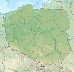
• coordinates | 50°17′48″N 20°51′17″E / 50.29667°N 20.85472°E |
| Length | 154 km (96 mi) |
| Basin size | 3,844 km2 (1,484 sq mi) |
| Discharge | |
| • average | 21.1 m3/s (750 cu ft/s) |
| Basin features | |
| Progression | Vistula→ Baltic Sea |
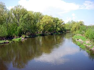
The Nida pronounced [ˈɲida] is a river in central Poland, a left tributary of the Vistula river, into which it flows near Nowy Korczyn). The Nida has a length of 154 kilometres and a basin area of 3,844 km2.[1] This includes the protected area called Nida Landscape Park.
The Nida itself is made up of two smaller rivers, the White Nida and the Black Nida, which merge in the village of Brzegi (near Checiny). It is a typical lowland river, with little difference in the water level. The valley of the Nida is wide, and covered with meadows. At its narrowest, the river is only 6 m wide, while at its widest spot, the Nida is 79 m across. The depth ranges from 0,4 to 2,6 m. The Nida is one of the warmest rivers of Poland; in the summer, its temperature reaches up to 27 degrees C.
