Back Nieuwegein Afrikaans نيواخاين Arabic Nieuwegein Catalan Gemeente Nieuwegein CEB Nieuwegein German Nieuwegein Esperanto Nieuwegein Spanish Nieuwegein Basque نیووهخین Persian Nieuwegein French
Nieuwegein | |
|---|---|
 Canal through Nieuwegein | |
 Location in Utrecht | |
| Coordinates: 52°2′N 5°5′E / 52.033°N 5.083°E | |
| Country | Netherlands |
| Province | Utrecht |
| Established | 1 July 1971 |
| Government | |
| • Body | Municipal council |
| • Mayor | Marijke van Beukering (D66) |
| Area | |
• Total | 25.65 km2 (9.90 sq mi) |
| • Land | 23.51 km2 (9.08 sq mi) |
| • Water | 2.14 km2 (0.83 sq mi) |
| Elevation | 1 m (3 ft) |
| Population (January 2021)[4] | |
• Total | 63,866 |
| • Density | 2,717/km2 (7,040/sq mi) |
| Demonym | Nieuwegeiner |
| Time zone | UTC+1 (CET) |
| • Summer (DST) | UTC+2 (CEST) |
| Postcode | 3430–3439 |
| Area code | 030 |
| Website | www |
 | |
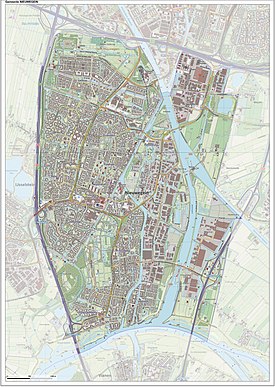
Nieuwegein (Dutch pronunciation: [ˌniu.əˈɣɛin] ) is a municipality and city in the Dutch province of Utrecht. It is bordered on the north by the city of Utrecht, the provincial capital. It is separated from Vianen to the south by the river Lek and borders on IJsselstein in the southwest and Houten in the east. Nieuwegein has 64,606 inhabitants as of 1 December 2021.
Several national sports federations are housed in Nieuwegein, including the NeVoBo (volleyball), KNZB (swimming), NBb (basketball) and KNCB (cricket).
There are three main secondary schools in the city, including the Anna van Rijn College, Oosterlicht College and the Cals College.
- ^ "Burgemeester Frans Backhuijs" [Mayor Frans Backhuijs] (in Dutch). Gemeente Nieuwegein. Archived from the original on 8 April 2014. Retrieved 8 April 2014.
- ^ "Kerncijfers wijken en buurten 2020" [Key figures for neighbourhoods 2020]. StatLine (in Dutch). CBS. 24 July 2020. Retrieved 19 September 2020.
- ^ "Postcodetool for 3431LZ". Actueel Hoogtebestand Nederland (in Dutch). Het Waterschapshuis. Retrieved 8 April 2014.
- ^ "Bevolkingsontwikkeling; regio per maand" [Population growth; regions per month]. CBS Statline (in Dutch). CBS. 1 January 2021. Retrieved 2 January 2022.

