Niezijl
Nijziel (Gronings) | |
|---|---|
Village | |
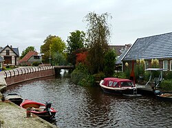
 The Hoerediep in Niezijl | |
| Coordinates: 53°16′N 6°21′E / 53.267°N 6.350°E | |
| Country | |
| Province | |
| Municipality | |
| Elevation | 0.9 m (3.0 ft) |
| Population (2021)[2] | |
| • Total | 420 |
| Time zone | UTC+1 (CET) |
| • Summer (DST) | UTC+2 (CEST) |
| Postcode | 9342[2] |
| Area code | 0594 |
Niezijl (Dutch pronunciation: [ˈni.zɛi̯l]; Gronings: Nijziel), historically Bomsterzijl (probably from bom, meaning 'low, water-enclosed piece of land'),[3] is a village in the municipality of Westerkwartier in the province of Groningen in the Netherlands. The village is located between Grijpskerk and Zuidhorn on the N355, the trunk highway from Leeuwarden to Groningen. As of 2021, Niezijl had a population of 420.[2] The village is intersected by two canals, the Niezijlsterdiep and the Hoerediep.
The village originally belonged to the Juursemakluft in the parish Grijpskerk. It got its own church in 1651 and has been an independent church ever since. South of the village, on the Van Starkenborgh Canal, is a restored polder mill, the Zwakkenburgermolen.
- ^ "Postcodetool for 9342PD". Actueel Hoogtebestand Nederland (in Dutch). Het Waterschapshuis. Retrieved 30 August 2023.
- ^ a b c d "Kerncijfers wijken en buurten 2021". Statistics Netherlands. Retrieved 30 August 2023.
- ^ Ligterink, G.H. (1968). Tussen Hunze en Lauwers: kultuur-historische schetsen uit het Groninger Westerkwartier. Groningen: Niemeijer. ISBN 9060621514.


