Back Nikunau Island CEB Nikunau German Νικουνάου Greek Nikunau Spanish Nikunau Estonian نیکوناو Persian Nikunau Finnish Nikunau French Nikunau Galician ניקונאו HE
 Nikunau Atoll | |
 | |
| Geography | |
|---|---|
| Location | Pacific Ocean |
| Coordinates | 1°21′S 176°27′E / 1.350°S 176.450°E |
| Archipelago | Gilbert Islands |
| Administration | |
| Capital | Utiroa |
| Former capital | Buariki |
| Demographics | |
| Population | 1,789 (2015 census) |
| Ethnic groups | I-Kiribati 99.7% |
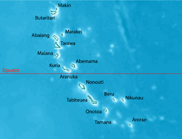
Nikunau is a low coral atoll in the Gilbert Islands that forms a council district of the Republic of Kiribati. It consists of two parts, with the larger in the northwest, joined by an isthmus about 150 metres (490 ft) wide.
There are several landlocked hypersaline lagoons within the island, covering about 30 hectares (74 acres). The island is surrounded by a narrow fringing reef. Its vegetation is moderately dense and consists largely of coconut palms and pandanus.[1]
The island's population includes 1,789 Kain Nikunau I-Kiribati people (at the most recent census). Typically, there are also a few other I-Kiribati, working for the Republic Government or the Nikunau Island Council. From time to time the United States Peace Corps and other I-Matang volunteers have been stationed there. Other residents over the years have included castaways and beachcombers in the days of whaling and itinerant trading, Protestant Samoan pastors, traders and agents running the island's trade stores and cooperatives (e.g. Andrew Turner, Tom Day, Frank Even, Kum Kee, Kwong), and Roman Catholic clergy.
Surfing on Nikunau depends on location, but averages 2 ft to 8 ft in height. The tip of the island, close to the airstrip, is where two tides meet, creating the largest waves, and strong tides and currents.[1]
- ^ a b "15. Nikunau" (PDF). Office of Te Beretitent - Republic of Kiribati Island Report Series. 2012. Retrieved 28 April 2015.


