Back نيسيروس ARZ Níssiros Catalan Nísos Nísyros CEB Nisyros Czech Nissiros Danish Nisyros German Νίσυρος Greek Nisiros Esperanto Nísiros Spanish نیسیروس Persian
Nisyros
Νίσυρος | |
|---|---|
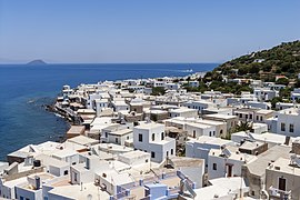
 view of Mandraki | |
| Coordinates: 36°35′N 27°10′E / 36.583°N 27.167°E | |
| Country | Greece |
| Administrative region | South Aegean |
| Regional unit | Kos |
| Area | |
• Municipality | 50.06 km2 (19.33 sq mi) |
| Highest elevation | 698 m (2,290 ft) |
| Lowest elevation | 0 m (0 ft) |
| Population (2021)[1] | |
• Municipality | 1,048 |
| • Density | 21/km2 (54/sq mi) |
| Time zone | UTC+2 (EET) |
| • Summer (DST) | UTC+3 (EEST) |
| Postal code | 853 03 |
| Area code(s) | 22420 |
| Vehicle registration | ΚΧ, ΡΟ, ΡΚ |
| Website | www.nisyros.gr |
Nisyros also spelled Nisiros (Greek: Νίσυρος, romanized: Nísyros; Modern Greek pronunciation: [ˈnisiros]) is a volcanic Greek island and municipality located in the Aegean Sea. It is part of the Dodecanese group of islands, situated between the islands of Kos and Tilos.
Its shape is approximately round, with a diameter of about 8 km (5 mi), and an area of 41.6 km2 (16.062 sq mi).[2] Several other islets are in the direct vicinity of Nisyros, the largest of which is Gyali, with a population of 22 citizens. The Municipality of Nisyros includes Gyalí, as well as uninhabited Pacheiá, Pergoússa, Kandelioussa, Ágios Antónios and Strongýli. It has a total land area of 50.055 km2 (19.326 sq mi)[3] and a total population of 1,048 inhabitants (2021). The island was also called Nisiro in Italian and İncirli in Turkish.
- ^ "Αποτελέσματα Απογραφής Πληθυσμού - Κατοικιών 2021, Μόνιμος Πληθυσμός κατά οικισμό" [Results of the 2021 Population - Housing Census, Permanent population by settlement] (in Greek). Hellenic Statistical Authority. 29 March 2024.
- ^ "City of Nisyros". Municipality of Nisyros. Retrieved 2008-01-22.
- ^ "Population & housing census 2001 (incl. area and average elevation)" (PDF) (in Greek). National Statistical Service of Greece.

