Back Normandië Afrikaans Normandiġ ANG نرمندية Arabic نورماندى ARZ Normandiya Azerbaijani نورماندی AZB Normandia (wawengkon administratip) BAN Нармандыя Byelorussian Нармандыя BE-X-OLD Normandi Breton
Normandy
| |
|---|---|
Geographical region | |
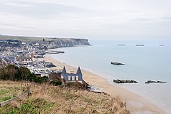
 Artificial port at Arromanches-les-Bains | |
 Location and extent of Normandy | |
| Coordinates: 48°53′N 0°10′E / 48.88°N 0.17°E | |
| Country | |
| Capitals | |
| French Departments and British Crown Dependencies | |
| Area | |
| • Total | 30,627 km2 (11,825 sq mi) |
| Population (2017) | |
| • Total | 3,499,280 |
| • Density | 110/km2 (300/sq mi) |
| Demonym | Norman[1] |
| Time zones | UTC+01:00 (CET) |
| • Summer (DST) | UTC+02:00 (CEST) |
| UTC+00:00 (GMT) | |
| • Summer (DST) | UTC+01:00 (BST) |
| ISO 3166 code | FR-NOR |
| Website | www |
Normandy (French: Normandie; Norman: Normaundie or Nouormandie)[note 2] is a geographical and cultural region in northwestern Europe, roughly coextensive with the historical Duchy of Normandy.
Normandy comprises mainland Normandy (a part of France) and insular Normandy (mostly the British Channel Islands). It covers 30,627 square kilometres (11,825 sq mi).[3] Its population in 2017 was 3,499,280. The inhabitants of Normandy are known as Normans;[1] the region is the historic homeland of the Norman language. Large settlements include Rouen, Caen, Le Havre and Cherbourg.
The cultural region of Normandy is roughly similar to the historical Duchy of Normandy, which includes small areas now part of the departments of Mayenne and Sarthe. The Channel Islands (French: Îles Anglo-Normandes) are also historically part of Normandy; they cover 194 square kilometres (75 sq mi)[4] and comprise two bailiwicks: Guernsey and Jersey, which are British Crown Dependencies.
Normandy's name comes from the settlement of the territory by Vikings ("Northmen") starting in the 9th century, and confirmed by treaty in the 10th century between King Charles III of France and the Viking jarl Rollo. For almost 150 years following the Norman conquest of England in 1066, Normandy and England were linked by having the same person reign as both Duke of Normandy and King of England.
Cite error: There are <ref group=note> tags on this page, but the references will not show without a {{reflist|group=note}} template (see the help page).
- ^ a b "Norman". WordReference.com. Archived from the original on 24 August 2017. Retrieved 23 April 2016.
3. a native or inhabitant of Normandy
- ^ "Norman". Online Etymology Dictionary. Archived from the original on 9 October 2017. Retrieved 1 April 2010.
- ^ Administrative Normandy Archived 1 May 2008 at the Wayback Machine
- ^ Michel Badet (29 May 2010). "Découvertes touristiques Cap Breizh – Les îles Anglo-Normandes". capbreizh.com. Archived from the original on 8 July 2011. Retrieved 8 October 2010.

