Back نورث بلات (نبراسكا) Arabic نورث بلات ARZ قوزئی پلت AZB North Platte Catalan Норт-Платт (Небраска) CE North Platte CEB North Platte, Nebraska Welsh North Platte DAG North Platte German North Platte (Nebraska) Spanish
North Platte | |
|---|---|
 Golden Spike Tower and Visitor Center at Union Pacific's Bailey Yards | |
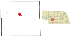
 Location of North Platte within Lincoln County and Nebraska | |
| Coordinates: 41°08′10″N 100°45′47″W / 41.13611°N 100.76306°W | |
| Country | United States |
| State | Nebraska |
| County | Lincoln |
| Government | |
| • Mayor | Brandon Kelliher[1] |
| Area | |
| • Total | 13.71 sq mi (35.50 km2) |
| • Land | 13.52 sq mi (35.02 km2) |
| • Water | 0.19 sq mi (0.48 km2) |
| Elevation | 2,802 ft (854 m) |
| Population (2020) | |
| • Total | 23,390 |
| • Density | 1,729.90/sq mi (667.93/km2) |
| Time zone | UTC−6 (Central (CST)) |
| • Summer (DST) | UTC−5 (CDT) |
| ZIP codes | 69101, 69103 |
| Area code | 308 |
| FIPS code | 31-35000 |
| GNIS feature ID | 2395260[3] |
| Website | www |
North Platte is a city in and the county seat of Lincoln County, Nebraska, United States.[4] It is located in the west-central part of the state, along Interstate 80, at the confluence of the North and South Platte Rivers forming the Platte River. The population was 23,390 at the 2020 census, making it the 11th most populous city in Nebraska.[5]
North Platte is a railroad town; Union Pacific Railroad's large Bailey Yard is located within the city. Today, North Platte is served only by freight trains, but during World War II the city was known for the North Platte Canteen, a volunteer organization serving food to millions of traveling soldiers.
North Platte is the principal city of the North Platte Micropolitan Statistical Area, which includes Lincoln, Logan, and McPherson counties.
- ^ von Kampen, Todd (November 3, 2020). "Brandon Kelliher wins North Platte mayoral contest". The North Platte Telegraph.
- ^ "ArcGIS REST Services Directory". United States Census Bureau. Retrieved September 18, 2022.
- ^ a b U.S. Geological Survey Geographic Names Information System: North Platte, Nebraska
- ^ "Find a County". National Association of Counties. Retrieved June 7, 2011.
- ^ "Explore Census Data". data.census.gov. Retrieved September 20, 2021.