Back Circars Catalan Circars septentrionales Spanish Circars septentrionaux French उत्तरनमक Hindi Sarkar Utara ID 北サルカール Japanese வடக்கு சர்க்கார் மாவட்டங்கள் Tamil ఉత్తర సర్కారులు Tegulu
| Northern Circars | |||||||||
|---|---|---|---|---|---|---|---|---|---|
| Division of British India | |||||||||
| 1823–1947 | |||||||||
|
Flag | |||||||||
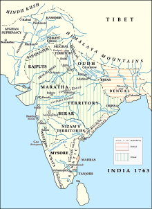
 The Northern Circars shortly after their occupation by the British | |||||||||
| Capital | Eluru | ||||||||
| Area | |||||||||
| • Coordinates | 17°27′N 83°00′E / 17.45°N 83.00°E | ||||||||
• | 78,000 km2 (30,000 sq mi) | ||||||||
| • Type | British Colonial Government | ||||||||
| Historical era | 20th century | ||||||||
• The British buy the rights over the Circars | 1823 | ||||||||
| 1947 | |||||||||
| |||||||||
| Today part of | |||||||||
The Northern Circars (also spelt Sarkars) was a division of British India's Madras Presidency. It consisted of a narrow slip of territory lying along the western side of the Bay of Bengal from 15° 40′ to 20° 17′ north latitude,[1] in the present-day Indian states of Andhra Pradesh and Odisha. The Subah of Deccan (Hyderabad/Golconda) consisted of 22 circars. These northern circars were five in number and the most prominent ones in the Subah.[2]
They became British in a protracted piecemeal process lasting from 1758 to 1823, involving diplomacy and financial settlements rather than military conquest. The annexation by the British of the Northern Circars deprived Hyderabad State, the Nizam's dominion, of the considerable coastline it formerly had, assuming the shape it is now remembered for that of a landlocked princely state with territories in Central Deccan, bounded on all sides by British India.[3]
- ^ One or more of the preceding sentences incorporates text from a publication now in the public domain: Chisholm, Hugh, ed. (1911). "Circar". Encyclopædia Britannica. Vol. 6 (11th ed.). Cambridge University Press. p. 380.
- ^ "Madras District Gazetteers, Volume 1". Superintendent, Government Press. 1915. p. 235.
- ^ P. N. Chopra, B.N. Puri & M.N. Das, A Comprehensive History of India, Volume 3. pg. 298
