Back Pulo-pulo Mariana Utara ACE Noordelike Mariana-eilande Afrikaans ስሜን ማሪያና ደሴቶች Amharic Norþerne Māriana Īegland ANG उत्तरी मैरियाना द्वीप ANP جزر ماريانا الشمالية Arabic جزر ماريانا الشماليه ARZ Islles Marianes del Norte AST Şimali Marian adaları Azerbaijani قوزئی ماریانا آدالاری AZB
Northern Mariana Islands | |
|---|---|
| Commonwealth of the Northern Mariana Islands[b] Sankattan Siha Na Islas Mariånas (Chamorro) Commonwealth Téél Falúw kka Efáng llól Marianas (Carolinian) | |
| Anthem: "Gi Talo Gi Halom Tasi" (Chamorro) "Satil Matawal Pacifiko" (Carolinian) ("In the Middle of the Sea") | |
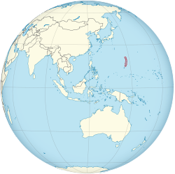
 Location of the Northern Mariana Islands (circled in red) | |
| Sovereign state | |
| Before association with the United States | Trust Territory of the Pacific Islands |
| Commonwealth status | January 9, 1978 |
| End of U.N. Trusteeship | November 4, 1986 |
| Capital and largest city | Saipan 15°11′N 145°44′E / 15.19°N 145.74°E |
| Official languages | |
| Other languages | Filipino |
| Ethnic groups (2023)[2] |
|
| Religion (2010)[3] |
|
| Demonym(s) | Northern Mariana Islander (formal) Northern Marianan (other) Marianan (diminutive form) Chamorro (colloquial)[4] |
| Government | Devolved presidential constitutional dependency |
| Joe Biden (D) | |
• Governor | Arnold Palacios (I) |
| David M. Apatang (I) | |
| Legislature | Commonwealth Legislature |
| Senate | |
| House of Representatives | |
| United States Congress | |
| Gregorio Sablan (D) | |
| Area | |
• Total | 464[5][6][7] km2 (179 sq mi) |
• Water (%) | negligible |
| Highest elevation | 965 m (3,166 ft) |
| Population | |
• 2022 estimate | 55,650[5] (209th) |
• 2020 census | 47,329[8] |
• Density | 113/km2 (292.7/sq mi) (97th) |
| GDP (PPP) | 2016 estimate |
• Total | $1.24 billion[5] |
• Per capita | $25,516[5] |
| GDP (nominal) | 2019 estimate |
• Total | $1.18 billion[9] |
• Per capita | $21,239 |
| HDI (2017) | 0.875 very high |
| Currency | United States dollar (US$) (USD) |
| Time zone | UTC+10:00 (ChST) |
| Date format | mm/dd/yyyy |
| Driving side | right |
| Calling code | +1-670 |
| USPS abbreviation | MP |
| Trad. abbreviation | CNMI |
| ISO 3166 code | |
| Internet TLD | .mp |
| Website | gov |
The Northern Mariana Islands, officially the Commonwealth of the Northern Mariana Islands (CNMI),[b][11] is an unincorporated territory and commonwealth of the United States consisting of 14 islands in the northwestern Pacific Ocean.[12] The CNMI includes the 14 northernmost islands in the Mariana Archipelago; the southernmost island, Guam, is a separate U.S. territory. The Northern Mariana Islands were listed by the United Nations as a non-self-governing territory until 1990.[13]
During the colonial period, the Northern Marianas were variously under the control of the Spanish, German, and Japanese empires. After World War II, the islands were part of the United Nations trust territories under American administration before formally joining the United States as a territory in 1986, with their population gaining United States citizenship.
The United States Department of the Interior cites a landmass of 183.5 square miles (475.26 km2).[14] According to the 2020 United States Census, 47,329 people were living in the CNMI at the time.[8] The vast majority of the population resides on Saipan, Tinian, and Rota. The other islands of the Northern Marianas are sparsely inhabited; the most notable among these is Pagan, which was left largely uninhabited since a 1981 volcanic eruption.[15]
The administrative center is Capitol Hill, a village in northwestern Saipan. The current governor of the CNMI is Arnold Palacios, who entered office in January 2023. The legislative branch has a 9-member Senate and a 20-member House of Representatives.
- ^ "U.S. Territories - Developments in the Law". Harvard Law Review. April 10, 2017. Retrieved June 11, 2024.
- ^ "Northern Mariana Islands". Britannica. Retrieved March 24, 2023.
- ^ "Northern Mariana Islands". Pew Research Center. Retrieved December 12, 2022.
- ^ "AAPI – Asian American and Pacific Islander – Primer". Environmental Protection Agency. June 28, 2006. Retrieved August 29, 2015.
- ^ a b c d Cite error: The named reference
CIA Factbookwas invoked but never defined (see the help page). - ^ Cite error: The named reference
CIA Factbook-bwas invoked but never defined (see the help page). - ^ "Our District". Congressman Gregorio Kilili Camacho Sablan Representing the Northern Mariana Islands. Archived from the original on November 5, 2020.
The U.S. Census Bureau reports the total land area of all islands as 179 square miles.
- ^ a b 2020 Census Population of the Commonwealth of the Northern Mariana Islands: Municipality and Village, U.S. Census Bureau.
- ^ "Northern Mariana Islands". World Bank Open Data. Retrieved August 9, 2021.
- ^ "7 fam 1120 acquisition of u.s. nationality in u.s. territories and possessions". U.S. Department of State Foreign Affairs Manual Volume 7- Consular Affairs. U.S. Department of State. January 3, 2013. Archived from the original (PDF) on December 22, 2015. Retrieved December 13, 2015.
- ^ (Chamorro: Sankattan Siha Na Islas Mariånas; Carolinian: Commonwealth Téél Falúw kka Efáng llól Marianas)
- ^ Lin, Tom C.W., Americans, Almost and Forgotten, 107 California Law Review (2019)
- ^ "List of former Trust and Non-Self-Governing Territories". United Nations. April 11, 2023. Retrieved April 11, 2023.
- ^ "Commonwealth of the Northern Mariana Islands". US Department of the Interior. Archived from the original on September 26, 2011.
- ^ "Pagan". Retrieved October 8, 2023.
Cite error: There are <ref group=lower-alpha> tags or {{efn}} templates on this page, but the references will not show without a {{reflist|group=lower-alpha}} template or {{notelist}} template (see the help page).

