Back Propinsi Occidental Mindoro ACE مندورو الغربية Arabic باتی میندورو AZB Occidental Mindoro BCL Mindoro Occidental Catalan Occidental Mindoro CBK-ZAM Kasadpang Mindoro CEB Occidental Mindoro German Mindoro Occidental Spanish میندورو غربی Persian
This article needs additional citations for verification. (October 2012) |
Occidental Mindoro | |
|---|---|
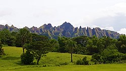
(from top: left to right) Iglit-Baco National Park, Sablayan, Landscape in San Jose, Dayap Bridge in Santa Cruz, Mindoro Mountains in Rizal and Devils Mountain in San Jose. | |
|
| |
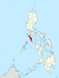
 Location in the Philippines | |
| Coordinates: 13°00′N 120°55′E / 13°N 120.92°E | |
| Country | Philippines |
| Region | Mimaropa |
| Founded | November 15, 1950 |
| Capital | Mamburao |
| Largest Municipality | San Jose |
| Government | |
| • Type | Sangguniang Panlalawigan |
| • Governor | Eduardo Gadiano (PFP) |
| • Vice Governor | Diana Apigo-Tayag (PFP) |
| • Representative | Leody F. Tarriela (PFP) |
| • Legislature | Occidental Mindoro Provincial Board |
| Area | |
| • Total | 5,865.71 km2 (2,264.76 sq mi) |
| • Rank | 11th out of 81 |
| Highest elevation | 2,488 m (8,163 ft) |
| Population (2020 census)[2] | |
| • Total | 525,354 |
| • Rank | 58th out of 81 |
| • Density | 90/km2 (230/sq mi) |
| • Rank | 71st out of 81 |
| Divisions | |
| • Independent cities | 0 |
| • Component cities | 0 |
| • Municipalities | |
| • Barangays | 164 |
| • Districts | Legislative district of Occidental Mindoro |
| Time zone | UTC+8 (PHT) |
| ZIP Code | 5100–5111 |
| IDD : area code | +63 (0)43 |
| ISO 3166 code | PH-MDC |
| Spoken languages | |
| Website | occidentalmindoro |
Occidental Mindoro (Tagalog: Kanlurang Mindoro), officially the Province of Occidental Mindoro (Tagalog: Lalawigan ng Kanlurang Mindoro or Lalawigan ng Occidental Mindoro), is a province in the Philippines located in the Mimaropa region. The province occupies the western half of the island of Mindoro. Its capital is Mamburao, but the most populous municipality is San Jose. Sablayan is its largest municipality in terms of area, occupying almost half of the entire province. As of 2020, Occidental Mindoro has 525,354 inhabitants.
The province is bordered on the east by the province of Oriental Mindoro, and on the south by the Mindoro Strait. The South China Sea is to the west of the province and Palawan is located to the southwest, across the Mindoro Strait. Batangas is to the north, separated by the Verde Island Passage, a protected marine area and the center of the world's marine biodiversity.
- ^ "List of Provinces". PSGC Interactive. Makati City, Philippines: National Statistical Coordination Board. Retrieved 29 October 2012.
- ^ Census of Population (2020). Table B - Population and Annual Growth Rates by Province, City, and Municipality - By Region. Philippine Statistics Authority. Retrieved 8 July 2021.


