Back مقاطعة أوغليثورب (جورجيا) Arabic Oglethorpe County, Georgia BAR Оугълторп (окръг, Джорджия) Bulgarian ওগ্লেথরপে কাউন্টি, জর্জিয়া BPY Oglethorpe Gông (Georgia) CDO Оглиторп (гуо, Джорджи) CE Oglethorpe County CEB Oglethorpe County, Georgia Welsh Oglethorpe County German Kantono Oglethorpe (Georgio) Esperanto
Oglethorpe County | |
|---|---|
 Oglethorpe County Courthouse | |
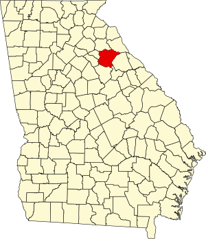
 Location within the U.S. state of Georgia | |
 Georgia's location within the U.S. | |
| Coordinates: 33°53′N 83°05′W / 33.88°N 83.08°W | |
| Country | |
| State | |
| Founded | December 19, 1795 |
| Named for | James Oglethorpe |
| Seat | Lexington |
| Largest city | Crawford |
| Area | |
| • Total | 442 sq mi (1,140 km2) |
| • Land | 439 sq mi (1,140 km2) |
| • Water | 3.0 sq mi (8 km2) 0.7% |
| Population (2020) | |
| • Total | 14,825 |
| • Density | 34/sq mi (13/km2) |
| Time zone | UTC−5 (Eastern) |
| • Summer (DST) | UTC−4 (EDT) |
| Congressional district | 10th |
| Website | oglethorpecountyga.gov |
Oglethorpe County is a county located in the northeastern part of the U.S. state of Georgia. As of the 2020 census, the population was 14,825.[1] The county seat is Lexington.[2]
Oglethorpe County is included in the Athens-Clarke County, GA Metropolitan Statistical Area, which is also included in the Atlanta-Athens-Clarke County-Sandy Springs, GA Combined Statistical Area. It is the largest county in Northeast Georgia.
- ^ "Census - Geography Profile: Oglethorpe County, Georgia". United States Census Bureau. Retrieved December 28, 2022.
- ^ "Find a County". National Association of Counties. Archived from the original on May 31, 2011. Retrieved June 7, 2011.

