Back مدينة وارسو القديمة Arabic Стары горад (Варшава) Byelorussian Стар град във Варшава Bulgarian Centre històric de Varsòvia Catalan Varšavské staré město Czech Warschauer Altstadt German Παλιά Πόλη της Βαρσοβίας Greek Centro histórico de Varsovia Spanish ورشو (منطقه تاریخی) Persian Vieille Ville (Varsovie) French
Old Town | |
|---|---|
Neighbourhood and City Information System area | |
| Stare Miasto | |
 The Castle Square, located in Old Town, in 2018 | |
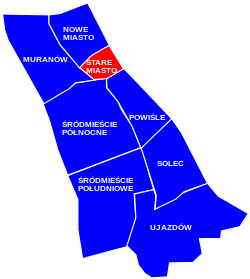
 The location of the neighbourhood of Old Town in the district of Śródmieście, in accordance to the City Information System | |
| Coordinates: 52°14′59″N 21°0′44″E / 52.24972°N 21.01222°E | |
| Country | |
| Voivodeship | Masovian Voivodeship |
| City county | Warsaw |
| District | Śródmieście |
| Municipal neighbourhood | Staromiejskie |
| Time zone | UTC+1 (CET) |
| • Summer (DST) | UTC+2 (CEST) |
| Official name | Historic Centre of Warsaw |
| Criteria | Cultural: (ii), (vi) |
| Designated | 1980 Minor boundary modification inscribed year: 2014 |
| Reference no. | 30bis |
| UNESCO region | Europe |
| Area | 25.93 ha (64.1 acres) |
| Buffer zone | 666.78 ha (1,647.6 acres) |
Warsaw Old Town,[a] also known as Old Town,[b] and historically known as Old Warsaw,[c][1] is a neighbourhood, and an area of the City Information System, in the city of Warsaw, Poland, located within the district of Śródmieście.[2] It is the oldest portion of the city, and contains numerous historic buildings, mostly from 17th and 18th centuries, such as the Royal Castle, city walls, St. John's Cathedral, and the Barbican, the Old Town Market Square and the Warsaw Mermaid Statue[3][4].[1][5] The settlement itself dates back to between the 13th and 14th centuries, and was granted town privileges c. 1300.[1][6]
During World War II, the Old Town was nearly totally destroyed, and subsequently reconstructed. The project was the world's first attempt to resurrect an entire historic city core and was included on the UNESCO World Heritage list in 1980.[7][8] The reconstruction efforts were again recognized in 2011 when all its documents and records were added to UNESCO's Memory of the World Programme.[9]
Cite error: There are <ref group=lower-alpha> tags or {{efn}} templates on this page, but the references will not show without a {{reflist|group=lower-alpha}} template or {{notelist}} template (see the help page).
- ^ a b c Encyklopedia Warszawy. Warsaw: Polish Scientific Publishers PWN, 1994, p. 806. ISBN 83-01-08836-2.
- ^ "Obszary MSI. Dzielnica Śródmieście". zdm.waw.pl (in Polish). Archived from the original on 2023-06-01. Retrieved 2023-03-12.
- ^ "Syrenka Warszawska" (in Polish). 2023-04-15. Retrieved 2024-11-03.
- ^ "Stare Miasto w Warszawie – odkrywamy warszawską starówkę". www.suerteprzewodnicy.pl (in Polish). 2024-09-28. Retrieved 2024-11-03.
- ^ Jerzy Lileyko: Najcenniejsze Zabytki Warszawy. Warsaw: Krajowa Agencja Wydawnicza, 1989, p. 30–36. ISBN 83-03-02485-X.
- ^ Robert Krzysztofik: Lokacje miejskie na obszarze Polski. Dokumentacja geograficzno-historyczna, Katowice, 2007, p. 80-81.
- ^ Stuart Dowell (21 July 2023). "Monumental reconstruction of Warsaw's Old Town which was devastated by WWII completed 70 years ago". thefirstnews.com. Archived from the original on 22 July 2023. Retrieved 22 July 2023.
- ^ "Historic Centre of Warsaw". UNESCO World Heritage Centre. Archived from the original on 15 March 2017. Retrieved 22 July 2023.
- ^ "Archive of Warsaw Reconstruction Office". en.unesco.com. Retrieved 22 July 2023.