Back Orizaba ALS اوريزابا Arabic Orizaba Catalan Оризаба (Оризаба, Веракрус) CE Orizaba (lungsod sa Mehiko, Estado de Veracruz-Llave, Orizaba) CEB Orizaba German Orizaba Esperanto Orizaba Spanish Orizaba Estonian Orizaba (udalerria) Basque
Orizaba | |
|---|---|
Municipality and town | |
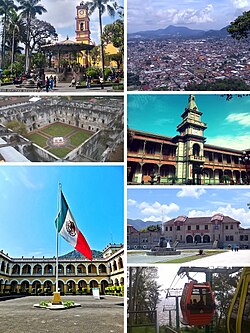
 Clockwise, from upper left: San Miguel de Arcángel Cathedral, Panoramic of the city from El Borrego Hill, San José de Gracia Convent, Palacio de Hierro, Orizaba City Hall, Mier y Pesado Polyforum, Orizaba cableway | |
 | |
| Country | |
| State | Veracruz |
| Government | |
| • Mayor | Juan Manuel Diez Francos (PRI) |
| Area | |
• Total | 27.9 km2 (10.8 sq mi) |
| Elevation | 1,235 m (4,052 ft) |
| Population (2020) | |
• Total | 123,182 |
| • Density | 4,416.7/km2 (11,439/sq mi) |
| • Seat | 120,500 |
| • Metro | 462,221 |
| Time zone | UTC−6 (Central Standard Time) |
| • Summer (DST) | UTC−5 (Central Daylight Time) |
Orizaba (Spanish: [oɾiˈsaβa] , Otomi: Mbo'ñu) is a city and municipality in the Mexican state of Veracruz. It is located 20 km west of its sister city Córdoba, and is adjacent to Río Blanco and Ixtaczoquitlán, on Federal Highways 180 and 190. The city had a 2020 census population of 120,500 and is almost coextensive with its small municipality, with only a few small areas outside the city. The municipality, with an area of 27.97 km2 (10.799 sq mi), had a population of 123,182.[1] While the metropolitan area of Orizaba has a population of 462,261 as 2020.
In the town of Ixhuatlancillo north of Orizaba, and in a large mountainous area to the south (the Sierra de Zongolica), live many thousands of people who speak a variant of Nahuatl which is often called Orizaba Nahuatl (ISO code nlv).
- ^ "Censo Orizaba 2020" (PDF) (in Spanish). Retrieved August 1, 2023.
