Back أوكسفورد (أوهايو) Arabic اوكسفورد (بتلر, اوهايو) ARZ آکسفورد، اوهایو AZB Оксфард (Агая) Byelorussian Oxford (Ohio) Catalan Оксфорд (Огайо) CE Oxford (lungsod sa Tinipong Bansa, Ohio) CEB Oxford, Ohio Welsh Oxford (Ohio) German Oxford (Ohio) Spanish
Oxford, Ohio | |
|---|---|
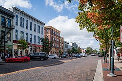
 Buildings along High Street in uptown Oxford. | |
 Location of Oxford in Butler County | |
| Coordinates: 39°30′27″N 84°44′48″W / 39.50750°N 84.74667°W | |
| Country | |
| State | |
| County | Butler |
| Chartered | 1809 |
| Platted | 1810 |
| Government | |
| • Type | Council-Manager |
| • Mayor | William B. Snavely[1] |
| • City Manager | Douglas R. Elliott, Jr.[2] |
| Area | |
| • Total | 7.78 sq mi (20.15 km2) |
| • Land | 7.78 sq mi (20.14 km2) |
| • Water | 0.00 sq mi (0.01 km2) |
| Elevation | 912 ft (278 m) |
| Population (2020) | |
| • Total | 23,035 |
| • Density | 2,962.70/sq mi (1,143.90/km2) |
| Time zone | UTC-05:00 (EST) |
| • Summer (DST) | UTC-04:00 (EDT) |
| ZIP code | 45056 |
| Area code | 513 |
| FIPS code | 39-59234[5] |
| GNIS feature ID | 2396116[4] |
| Website | www |
Oxford is a city in northwestern Butler County, Ohio, United States. The population was 23,035 at the 2020 census.[6] A college town, Oxford was founded as a home for Miami University and lies in the southwestern portion of the state approximately 40 miles (64 km) northwest of Cincinnati and 40 miles (64 km) southwest of Dayton. It is part of the Cincinnati metropolitan area.
- ^ "City Council". City of Oxford, Ohio. Retrieved March 1, 2023.
- ^ "City Manager - City of Oxford, Ohio | Home of Miami University". www.cityofoxford.org. Retrieved July 6, 2024.
- ^ "ArcGIS REST Services Directory". United States Census Bureau. Retrieved September 20, 2022.
- ^ a b U.S. Geological Survey Geographic Names Information System: Oxford, Ohio
- ^ "U.S. Census website". United States Census Bureau. Retrieved January 31, 2008.
- ^ "QuickFacts: Oxford city, Ohio". census.gov. Retrieved September 13, 2021.

