Back Oxley-Wild-Rivers-Nationalpark German Parque nacional Ríos Salvajes de Oxley Spanish Parc national des Oxley Wild Rivers French ოქსლის ველური მდინარეების ეროვნული პარკი Georgian ഓക്സ്ലി വൈൽഡ് റിവേഴ്സ് ദേശീയോദ്യാനം Malayalam Nationaal park Oxley Wild Rivers Dutch Oxley Wild Rivers nasjonalpark NB Park Narodowy Oxley Wild Rivers Polish Oxley Wild Rivers National Park SIMPLE
| Oxley Wild Rivers National Park New South Wales | |
|---|---|
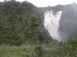
 Apsley Falls, located within the national park | |
| Nearest town or city | Yarrowitch |
| Coordinates | 30°59′47″S 152°00′36″E / 30.99639°S 152.01000°E |
| Established | 26 September 1986[1] |
| Area | 1,452.33 km2 (560.7 sq mi)[1] |
| LGA(s) | Port Macquarie Hastings City Council Walcha Shire |
| Managing authorities | NSW National Parks & Wildlife Service |
| Website | Oxley Wild Rivers National Park |
| See also | Protected areas of New South Wales |
The Oxley Wild Rivers National Park is a protected national park that is located in the Northern Tablelands region of New South Wales, Australia in the Port Macquarie-Hastings City Council and Walcha Shire councils. The 145,223-hectare (358,850-acre) park is situated 445 kilometres (277 mi) north of Sydney and is named in memory of the Australian explorer John Oxley, who passed through the area in 1818 and is one of the largest national parks in New South Wales.[2]
The park is part of the Hastings-Macleay Group World Heritage Site Gondwana Rainforests of Australia inscribed in 1986[3] and added to the Australian National Heritage List in 2007.[4]
The Oxley Wild Rivers National Park (OWRNP) was World Heritage listed in recognition of the extensive dry rainforest that occurs within the park, and the associated rich biodiversity that includes several rare or threatened plants and animals. There are at least fourteen waterfalls in the park.[5]
- ^ a b "Oxley Wild Rivers National Park: Park Management". Office of Environment and Heritage. Government of New South Wales. Retrieved 10 September 2014.
- ^ Guide to NSW National Parks. NSW National Parks & Wildlife Service. 2008.
- ^ "Gondwana Rainforests of Australia". Department of the Environment. Australian Government. Retrieved 10 September 2014.
- ^ "Gondwana Rainforests of Australia, Lismore, NSW, Australia". Australian Heritage Database: Department of the Environment. Australian Government. 2014. Retrieved 10 September 2014.
- ^ Reader's Digest Guide to Australian Places. Sydney: Reader's Digest.
