Paya Lebar | |
|---|---|
| Other transcription(s) | |
| • Malay | Paya Lebar (Rumi) ڤايا ليبر (Jawi) |
| • Chinese | 巴耶利峇 Bāyē Lìbā (Pinyin) Pa-iâ Lī-bā (Hokkien POJ) |
| • Tamil | பாய லேபார் Pāya lēpar (Transliteration) |
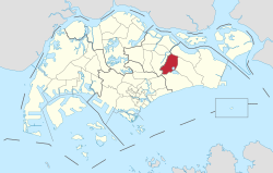
 Location of Paya Lebar in Singapore | |
| Coordinates: 1°21′12″N 103°53′37″E / 1.3533°N 103.8937°E | |
| Country | |
| Region | East
|
| Government | |
| • Mayors | ---- |
| Area | |
• Total | 11.69 km2 (4.51 sq mi) |
| Population (2022) | |
• Total | 30 |
| • Density | 2.6/km2 (6.6/sq mi) |
| Ethnic groups | |
Paya Lebar (/ˈpɑːjɑː ˌleɪbɑː/ PAH-ya LAY-bar) is a planning area located in the East Region of Singapore, bordered by Hougang to the west, Sengkang to the northwest, Tampines to the east, Bedok to the south and Pasir Ris to the north.
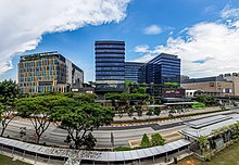
As part of the Singapore Urban Redevelopment Authority's (URA) Master Plan 2014,[1] Paya Lebar Central[2] was identified as one of the five growth areas. It was since earmarked as an up-and-coming commercial hub, in line with the wider decentralisation strategy to ensure the city's sustainable growth. Paya Lebar participates in the pilot Business Improvement District (BID) programme.
Although they have similar names, Paya Lebar Central, Paya Lebar MRT Station and Paya Lebar Road are not part of Paya Lebar Planning Area, instead are part of Geylang East planning subzone, part of Geylang.

- ^ "Master Plan 2014". www.ura.gov.sg.
- ^ "Paya Lebar Central". www.ura.gov.sg. Archived from the original on 13 February 2019.

