Back Peace River Regional District CEB Peace River Regional District German District régional de Peace River French Distretto regionale di Peace River Italian ピースリバー地域 Japanese Peace River (dystrykt regionalny) Polish ضلع پیس رور PNB Distrito Regional de Peace River Portuguese Пис-Ривер (округ) Russian Distrikti rajonal Peace River Albanian
Peace River | |
|---|---|
| Peace River Regional District | |
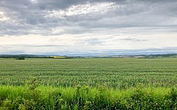
 Rolling grass hills just outside Fort St. John | |
Major communities | |
 Location in British Columbia | |
| Country | Canada |
| Province | British Columbia |
| Administrative office location | Dawson Creek |
| Government | |
| • Type | Regional district |
| • Body | Board of Directors |
| • Chair | Brad Sperling (C) |
| • Vice Chair | Dan Rose (E) |
| • Electoral Areas | |
| Area | |
| • Land | 117,387.55 km2 (45,323.59 sq mi) |
| Population (2016)[2] | |
| • Total | 62,942 |
| • Density | 0.536/km2 (1.39/sq mi) |
| Time zones | |
| Most of the district | UTC−07:00 (Mountain Time Zone) |
| Electoral area B / Tsay Keh Dene / Kwadacha | UTC−08:00 (Pacific Time Zone) |
| • Summer (DST) | UTC−07:00 (Pacific Daylight Time) |
| Website | prrd |
The Peace River Regional District is a regional district in northeastern British Columbia, Canada. The regional district comprises seven municipalities and four electoral areas. Its member municipalities are the cities of Fort St. John and Dawson Creek, the district municipalities of Tumbler Ridge, Chetwynd, Taylor, and Hudson's Hope, and the village of Pouce Coupe. The district's administrative offices are in Dawson Creek.
The regional district also has four regional district electoral areas: B, C, D and E. Six Indian reserves and one Indian settlement are located within the regional district's boundaries, but are not governed by the regional district.
Its modern boundaries were established on October 31, 1987, when the Peace River-Liard Regional District was divided in two. The separated northern territories became the Fort Nelson-Liard Regional District,[3] now the Northern Rockies Regional Municipality.[4]
Located east of the Rockies, the regional district is characterized by rolling hills with grain and cattle farms. About 40% of the province's Agricultural Land Reserve is situated within the regional district. The Peace River flows west-to-east through the middle of the eastern half of the regional district. West of the Rockies the terrain is severe mountain wilderness with few roads and only a handful of inhabitants. Its total land area is 119,200.1 km2 (46,023.42 sq mi), the largest regional district in British Columbia in area. (The Stikine Region is larger, but is not a regional district.) The total population reported in the 2006 census was 58,264 with 24,019 private dwellings, up from 55,080 people in 2001.
- ^ "Board". Retrieved July 9, 2019.
- ^ a b "Population and dwelling counts, for Canada, provinces and territories, and census divisions, 2016 and 2011 censuses – 100% data (British Columbia)". Statistics Canada. February 8, 2017. Retrieved July 9, 2019.
- ^ BC Names/GeoBC "Peace River-Liard Regional District"
- ^ BC Names/GeoBC entry "Fort Nelson-Liard Regional District

