Back نهر بينا Arabic نهر بينا ARZ پننا چایی AZB পেননা নদী Bengali/Bangla Pennar Breton Penner Catalan Penner River CEB Пеннар (юханшыв) CV Pennar German Río Pennar Spanish
| Penna Penneru, Penner, Pennar or Uttara Pinakini | |
|---|---|
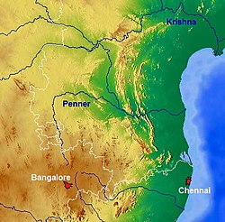
 Map showing the river | |
 | |
| Location | |
| Country | India |
| State | Andhra Pradesh, Karnataka |
| Region | South India |
| District | Chikkaballapura, Kolaru, Tumakuru, Sri Sathya Sai district, Kadapa and Nellore |
| Cities | Chikkaballapura, Gauribidanuru, Hindupuram, Ananthapuram, Tadipatri Proddaturu, Kadapa, Nellore |
| Physical characteristics | |
| Source | South India |
| • location | 13°23′N 77°37′E / 13.39°N 77.61°E, Chikkaballapur district, Nandi Hills, Karnataka, India |
| Mouth | Bay of Bengal |
• location | 14°35′N 80°08′E / 14.58°N 80.14°E, Nellore, Utukuru, Andhra Pradesh, India |
• elevation | 0 m (0 ft) |
| Length | 597 km (371 mi) |
| Basin size | 55,213 km2 (21,318 sq mi) |
| Discharge | |
| • location | Nellore (1965–1979 average), max (1991)[1] |
| • average | 200.4 m3/s (7,080 cu ft/s) |
| • minimum | 0 m3/s (0 cu ft/s) |
| • maximum | 1,876 m3/s (66,300 cu ft/s) |
| Basin features | |
| Tributaries | |
| • left | Kunderu, Sagileru |
| • right | Jayamangali,Chitravathi, Papagni, Cheyyeru |
Penna (also known as Pinakini, Penneru, Penner, Pennar, Pennai) is a river of southern India. This is a unique river in world where after originating from Nandi hills, it flows as two different streams, one in North and South directions. The Penna rises in the Nandi Hills in Chikkaballapur District of Karnataka state, and runs north and east through the states of Karnataka and Andhra Pradesh to empty into bay of bengal in Andhra Pradesh. It is 597 kilometres (371 mi) long, with a drainage basin covering 55,213 km2:[2] 6,937 km2 in Karnataka and 48,276 km2 in Andhra Pradesh. Along with this main stream there is another stream south towards Tamilnadu with the name Then Pennai or south Pennar which further moves towards the east to empty into the Bay of Bengal. The Penna river basin lies in the rain shadow region of Eastern Ghats and receives 500 mm average rainfall annually.
- ^ Kumar, Rakesh; Singh, R.D.; Sharma, K.D. (10 September 2005). "Water Resources of India" (PDF). Current Science. 89 (5). Bangalore: Current Science Association: 794–811. Retrieved 13 October 2013.
- ^ Garg, Santosh Kumar (1999). International and interstate river water disputes. Laxmi Publications. pp. 7–8. ISBN 978-81-7008-068-8. Retrieved 16 May 2011.