Back مقاطعة بيري (إلينوي) Arabic Perry County, Illinois BAR Пери (окръг, Илинойс) Bulgarian পেরী কাউন্টি, ইলিনয়স BPY Perry Gông (Illinois) CDO Перри (гуо, Иллинойс) CE Perry County (kondado sa Tinipong Bansa, Illinois) CEB Perry County, Illinois Welsh Perry County (Illinois) German Κομητεία Πέρι (Ιλινόι) Greek
Perry County | |
|---|---|
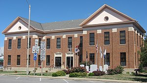
 Perry County Courthouse in Pinckneyville | |
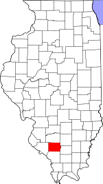
 Location within the U.S. state of Illinois | |
 Illinois's location within the U.S. | |
| Coordinates: 38°05′N 89°22′W / 38.09°N 89.37°W | |
| Country | |
| State | |
| Founded | January 29, 1827 |
| Named for | Oliver Hazard Perry |
| Seat | Pinckneyville |
| Largest city | Du Quoin |
| Area | |
| • Total | 447 sq mi (1,160 km2) |
| • Land | 442 sq mi (1,140 km2) |
| • Water | 5.2 sq mi (13 km2) 1.2% |
| Population (2020) | |
| • Total | 20,945 |
| • Density | 47/sq mi (18/km2) |
| Time zone | UTC−6 (Central) |
| • Summer (DST) | UTC−5 (CDT) |
| Congressional district | 12th |
| Website | perryil |
Perry County is a county in Illinois. According to the 2020 census, it had a population of 20,945.[1] Its county seat is Pinckneyville.[2] It is located in the southern portion of Illinois known as "Little Egypt".
- ^ "Perry County, Illinois". United States Census Bureau. Retrieved June 10, 2023.
- ^ "Find a County". National Association of Counties. Retrieved June 7, 2011.