Back بيتون (منطقة) Arabic Petone CEB Petone German Petone French Petone Italian Petone Malay Petone NN Petone Portuguese پیٹون Urdu
Petone | |
|---|---|
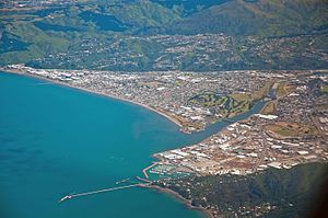
 Aerial view of Petone and Seaview | |
 | |
| Coordinates: 41°13′30.00″S 174°52′40.80″E / 41.2250000°S 174.8780000°E | |
| Country | New Zealand |
| City | Lower Hutt |
| Local authority | Hutt City Council |
| Electoral ward | Harbour |
| Community board | Petone Community Board[1] |
| Established | 1840 |
| Area | |
| • Land | 390 ha (960 acres) |
| Population (June 2024)[3] | |
• Total | 8,370 |
| Postcode(s) | 5012 |
| Train stations | Petone Railway Station Ava Railway Station |
| Korokoro | Maungaraki | Alicetown |
| Horokiwi |
|
Moera |
| Wellington Harbour | Seaview |

Petone (Māori: Pito-one) is a large suburb of Lower Hutt, Wellington. It stands at the southern end of the Hutt Valley, on the northern shore of Wellington Harbour.
Europeans first settled in Petone in January 1840, making it the oldest European settlement in the Wellington Region. It became a borough in 1888, and merged with Lower Hutt (branded as "Hutt City") in 1989. In November 2023, Hutt City Council decided to consult the New Zealand Geographic Board about changing the suburb's name to "Pito-one" - the area's original Māori name.[4]
- ^ "Hutt City Wards and Suburbs" (PDF). Hutt City Council. Archived from the original (PDF) on 9 February 2013. Retrieved 25 May 2022.
- ^ Cite error: The named reference
Areawas invoked but never defined (see the help page). - ^ "Aotearoa Data Explorer". Statistics New Zealand. Retrieved 26 October 2024.
- ^ Knell, Conor; Boyack, Nicholas (22 November 2023). "How does Petone feel about Pito-one?". thepost.co.nz. Retrieved 22 November 2023.