Back فوكيس Arabic Fokida Azerbaijani Фокида Bulgarian Fokis Breton Unitat perifèrica de Fòcida Catalan Nomós Fokídos CEB Fókida Czech Phocis Welsh Fokis Danish Fokida German
Phocis
Περιφερειακή ενότητα Φωκίδας | |
|---|---|
 Municipalities of Phocis | |
| Coordinates: 38°30′N 22°15′E / 38.500°N 22.250°E | |
| Country | Greece |
| Administrative region | Central Greece |
| Seat | Amfissa |
| Area | |
| • Total | 2,120 km2 (820 sq mi) |
| Population (2021)[1] | |
| • Total | 36,199 |
| • Density | 17/km2 (44/sq mi) |
| Time zone | UTC+2 (EET) |
| • Summer (DST) | UTC+3 (EEST) |
| Postal code | 33x xx |
| Area code(s) | 226x0, 26340 |
| Vehicle registration | ΑΜ |
| Website | www |
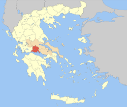
Phocis (/ˈfoʊsɪs/; Greek: Φωκίδα [foˈciða]; Ancient Greek: Φωκίς) is one of the regional units of Greece. It is part of the administrative region of Central Greece. It stretches from the western mountainsides of Parnassus on the east to the mountain range of Vardousia on the west, upon the Gulf of Corinth. It is named after the ancient region of Phocis, but the modern regional unit also includes parts of ancient Aetolia, Locris and Doris.
- ^ "Αποτελέσματα Απογραφής Πληθυσμού - Κατοικιών 2021, Μόνιμος Πληθυσμός κατά οικισμό" [Results of the 2021 Population - Housing Census, Permanent population by settlement] (in Greek). Hellenic Statistical Authority. 29 March 2024.

