Back جسر غار Arabic Ponte del Gard AST Pont du Gard BAN Пон-дзю-Гар Byelorussian पोंट डु गार्ड Bihari Pont ar Gard Breton Pont del Gard Catalan Pont du Gard Czech Pont du Gard Welsh Pont du Gard Danish
Pont du Gard | |
|---|---|
 | |
| Coordinates | 43°56′50″N 04°32′08″E / 43.94722°N 4.53556°E |
| Carries | Roman aqueduct of Nîmes |
| Crosses | Gardon River |
| Locale | Vers-Pont-du-Gard, Gard, France |
| Maintained by | Public Association of Cultural Cooperation (since 2003) |
| Website | pontdugard |
| Characteristics | |
| Design | Arch bridge |
| Material | Shelly limestone |
| Total length |
|
| Width |
|
| Height |
|
| No. of spans |
|
| Piers in water | 5 |
| History | |
| Construction end | c. 40–60 AD |
| Construction cost | 30 million sesterces (est.) |
| Closed | c. 6th century |
| Official name | Pont du Gard (Roman Aqueduct) |
| Type | Cultural |
| Criteria | i, iii, iv |
| Designated | 1985 (9th session) |
| Reference no. | 344 |
| Region | Europe and North America |
| Designated | 1840 |
| Reference no. | PA00103291 |
| Location | |
 | |
| References | |
| [1][2] | |
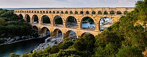
The Pont du Gard is an ancient Roman aqueduct bridge built in the first century AD to carry water over 50 km (31 mi) to the Roman colony of Nemausus (Nîmes).[3] It crosses the river Gardon near the town of Vers-Pont-du-Gard in southern France. The Pont du Gard is one of the best preserved Roman aqueduct bridges. It was added to UNESCO's list of World Heritage sites in 1985 because of its exceptional preservation, historical importance, and architectural ingenuity.[4]
- ^ "EPCC du Pont du Gard". Culture-epcc.fr. 2008. Retrieved 28 July 2012.
- ^ Base Mérimée: PA00103291, Ministère français de la Culture. (in French)
- ^ "Map of the Roman Aqueduct to Nîmes". Athena Review Image Archive. Athena Review. Archived from the original on 2017-11-15. Retrieved 2015-09-02.
- ^ "Pont du Gard (Roman Aqueduct)". UNESCO World Heritage Centre. United Nations Educational, Scientific, and Cultural Organization. Retrieved 17 October 2021.