Back محافظة بورسعيد Arabic محافظة بورسعيد ARZ پورتسعید اوستانی AZB Порт-Саід (мухафаза) Byelorussian Порт-Саід (мугафаза) BE-X-OLD Порт Саид (област) Bulgarian Port Said (guvernorat) BS Governació de Port Saïd Catalan Muḩāfaz̧at Būr Sa‘īd CEB Port Said (guvernorát) Czech
31°16′N 32°18′E / 31.267°N 32.300°E
Port Said Governorate | |
|---|---|
 | |
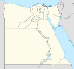
 Port Said Governorate on the map of Egypt | |
| Country | |
| Seat | Port Said (capital) |
| Government | |
| • Governor | Adel Mohamed Ibrahim Yousef Al Ghadhban[1] |
| Area | |
• Total | 1,345 km2 (519 sq mi) |
| Population (January 1, 2023)[2] | |
• Total | 789,241 |
| • Density | 590/km2 (1,500/sq mi) |
| GDP | |
| • Total | EGP 190 billion (US$ 12.1 billion) |
| Time zone | UTC+2 (EGY) |
| HDI (2021) | 0.799[4] high · 1st |
| Website | [1] |
Port Said Governorate[5] (Arabic: محافظة بورسعيد, romanized: Muḩāfaz̧at Būr Sa'īd) is a subdivision located at the northeast end of the Nile Delta, on the coast of the Mediterranean Sea at the northern mouth of the Suez Canal. It is wholly urban,[6] comprising the original Port Said city on the west bank of the Suez Canal, and the town of Port Fuad on the eastern bank, which makes it one of the few transcontinental metropolitans in the world, as it spans across two continents (Africa/Asia).[7]
Port Said is one of six governorates that make up the Suez Canal economic region, and is the home of the Suez Canal Authority historical administrative building and the Lighthouse of Port Said.
- ^ "Egypt names six provincial governors, mostly ex-generals" رسمياً.. المحافظون الجدد ونوابهم يؤدون اليمين الدستورية أمام الرئيس. Almasry Alyoum (in Arabic). 30 August 2018.
- ^ "ﻋـــﺩﺩ ﺍﻟﺳﻛــﺎﻥ ﺍﻟﺗﻘﺩﻳﺭﻯ ﻟﻸﻗﺳــﺎﻡ" (PDF) (in Arabic). Retrieved 1 April 2023.
- ^ "GDP BY GOVERNORATE", mped.gov.eg
- ^ "Sub-national HDI - Subnational HDI - Table - Global Data Lab". globaldatalab.org. Retrieved 20 February 2023.
- ^ "Muḩāfaz̧at Būr Sa'īd". Geonames. Archived from the original on 20 October 2016. Retrieved 20 October 2016.
- ^ "Population Estimates By Governorate ( Urban /Rural ) 1/1/2018". www.capmas.gov.eg. Retrieved 10 October 2018.
- ^ "About - Administrative Division". portsaid.gov.eg. Retrieved 3 January 2024.

