Back Портмадог Bulgarian Porthmadog Breton Porthmadog (kapital sa komunidad) CEB Porthmadog Welsh Porthmadog Danish Porthmadog German Πόρθμαντογκ Greek Porthmadog Spanish Porthmadog Basque پورثمدوگ Persian
| Porthmadog | |
|---|---|
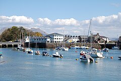
 Porthmadog Harbour was developed to export slate | |
Location within Gwynedd | |
| Area | 16.18 km2 (6.25 sq mi) |
| Population | 4,185 (2011) |
| • Density | 259/km2 (670/sq mi) |
| OS grid reference | SH565385 |
| Community |
|
| Principal area | |
| Preserved county | |
| Country | Wales |
| Sovereign state | United Kingdom |
| Post town | PORTHMADOG |
| Postcode district | LL49 |
| Dialling code | 01766 |
| Police | North Wales |
| Fire | North Wales |
| Ambulance | Welsh |
| UK Parliament | |
| Senedd Cymru – Welsh Parliament | |
Porthmadog (Welsh: [pɔrθˈmadɔɡ] ), originally Portmadoc until 1974 and locally as "Port",[1] is a coastal town and community in the Eifionydd area of Gwynedd, Wales, and the historic county of Caernarfonshire. It lies 5 miles (8 km) east of Criccieth, 11 miles (18 km) south-west of Blaenau Ffestiniog, 25 miles (40 km) north of Dolgellau and 20 miles (32 km) south of Caernarfon. The community population of 4,185 in the 2011 census was put at 4,134 in 2019.[2] It grew in the 19th century as a port for local slate, but as the trade declined, it continued as a shopping and tourism centre, being close to Snowdonia National Park and the Ffestiniog Railway.[3] The 1987 National Eisteddfod was held there.[4] It includes nearby Borth-y-Gest, Morfa Bychan and Tremadog.[5]
- ^ "What's in a name: Porthmadog". British Broadcasting Corporation. Archived from the original on 14 November 2012. Retrieved 17 April 2013.
- ^ "Porthmadog". City Population. Retrieved 23 December 2020.
- ^ Whispernet (14 February 2008). "Gateway to Snowdonia". Porthmadog. Retrieved 17 April 2013.
- ^ "Eisteddfod Genedlaethol Cymru: Eisteddfod Locations". Eisteddfod.org.uk. Archived from the original on 23 May 2011. Retrieved 17 April 2013.
- ^ "Ordnance Survey: Election Maps: Gwynedd". Election-maps.co.uk. Retrieved 17 April 2013.
