Back پوینتون-ویت-وورث AZB Poynton CEB Poynton Welsh Poynton Spanish Poynton Basque پوینتون-ویت-وورث Persian Poynton French Poynton Italian Poynton Dutch Poynton Polish
| Poynton | |
|---|---|
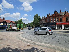
 Poynton shared space town centre, remodelled in 2011 | |
Location within Cheshire | |
| Area | 13.1 km2 (5.1 sq mi) [1] |
| Population | 14,260 (2011 census)[2] |
| • Density | 1,089/km2 (2,820/sq mi) |
| OS grid reference | SJ925835 |
| • London | 152 mi (245 km) |
| Civil parish |
|
| Unitary authority | |
| Ceremonial county | |
| Region | |
| Country | England |
| Sovereign state | United Kingdom |
| Post town | STOCKPORT |
| Postcode district | SK12 |
| Dialling code | 01625 |
| Police | Cheshire |
| Fire | Cheshire |
| Ambulance | North West |
| UK Parliament | |
Poynton is a town in the civil parish of Poynton-with-Worth, in the Cheshire East district and the ceremonial county of Cheshire, England; from 1974 to 2009 it was in Macclesfield district. It is located on the easternmost fringe of the Cheshire Plain, 11 miles (18 km) south-east of Manchester, 7 miles (11 km) north of Macclesfield and 5 miles (8 km) south of Stockport.
The first mention of the manor of Poynton was in 1289. Coal was mined in Poynton from the 16th century and the collieries, under the ownership of the Lords Vernon from 1832 until their closure in 1935, were the largest in Cheshire. Consequent urbanisation and socioeconomic development necessitated better transport links; these came with the completion of the Macclesfield Canal through Poynton in 1831, the arrival of the Manchester and Birmingham Railway in 1845 and the Macclesfield, Bollington and Marple Railway in 1869. In the late 20th century, Poynton became a commuter town for Manchester. Since 1945, the population has nearly trebled to 14,260 in 2011.[2]
- ^ "City Population". Retrieved 19 June 2020.
- ^ a b UK Census (2011). "Local Area Report – Poynton-with-Worth Parish (1170220106)". Nomis. Office for National Statistics. Retrieved 21 March 2018.
