Back إقليم بواني Arabic TanzaniaPwaniGola AVK Пвани (регион) Bulgarian Regió de Pwani Catalan Coast Region CEB ھەرێمی پوانی CKB Pwani (Tanzania) Danish Pwani (Region) German Περιφέρεια Πουάνι Greek Regiono Pwani Esperanto
Pwani Region
Mkoa wa Pwani (Swahili) | |
|---|---|
|
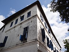
From top to bottom: Bird's eye view of Bagamoyo District, Coconut landscape of Mkuranga District and Bagamoyo | |
| Etymology: The Coast | |
| Nickname: Beautiful Pwani | |
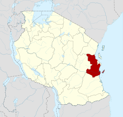
 Location in Tanzania | |
| Coordinates: 7°19′25.68″S 38°49′13.8″E / 7.3238000°S 38.820500°E | |
| Country | |
| Zone | Coastal |
| Administrative Region | 1972 |
| Capital | Kibaha |
| Districts | |
| Government | |
| • Regional Commissioner | Abubakar Kunenge |
| Area | |
| • Total | 32,547 km2 (12,566 sq mi) |
| • Rank | 13th of 31 |
| Highest elevation (Pongwe) | 874 m (2,867 ft) |
| Population (2022) | |
| • Total | 2,024,947 |
| • Rank | 15th of 31 |
| • Density | 62/km2 (160/sq mi) |
| Demonym | Pwanian |
| Ethnic groups | |
| • Settler | Swahili |
| • Native | Zaramo, Ndengereko, Rufiji, Kwere, Doe & Zigua |
| Time zone | UTC+3 (EAT) |
| Postcode | 61xxx |
| ISO 3166 code | TZ-19 |
| HDI (2021) | 0.525[1] low · 16th of 25 |
| Website | Official website |
| Symbols of Tanzania | |
| Bird | |
| Butterfly | |
| Fish | |
| Mammal |  |
| Tree | |
| Mineral |  |
Pwani Region (Mkoa wa Pwani in Swahili) is one of Tanzania's 31 administrative regions. The word "Pwani" in Swahili means the "coast". With the town of Kibaha serving as the capital, the region borders the Tanga Region to the north, Morogoro Region to the west, Lindi Region to the south, and surrounds Dar es Salaam Region to the east. The Indian Ocean also borders the region to its northeast and southeast. The region is home to Mafia Island, the Rufiji delta and Saadani National Park. The region is home to Bagamoyo town, a historical Swahili settlement, and the first colonial capital of German East Africa. According to the 2012 national census, the region had a population of 1,098,668, which was slightly lower than the pre-census projection of 1,110,917.[2]: page 2 From 2002 to 2012, the region's 2.2 percent average annual population growth rate was the seventeenth-highest in the country.[2]: page 4 It was also the 21st most densely populated region with 34 people per square kilometre.,[2]: page 6 [3] According to the 2022 census the population had nearly doubled to 2,024,947.[4] The region is slightly larger than Belgium (32,133 square kilometres (12,407 sq mi)).
- ^ "Sub-national HDI - Area Database - Global Data Lab". hdi.globaldatalab.org. Archived from the original on 2018-09-23. Retrieved 2020-02-26.
- ^ a b c Population Distribution by Administrative Units, United Republic of Tanzania, 2013 Archived 2013-05-02 at the Wayback Machine
- ^ Statistical Abstract 2011, Tanzania National Bureau of Statistics Archived 2013-11-05 at the Wayback Machine
- ^ "Tanzania: Regions and Cities - Population Statistics, Maps, Charts, Weather and Web Information". www.citypopulation.de. Retrieved 2024-02-09.


